

Latest Version
Version
0.11.0
0.11.0
Update
July 19, 2025
July 19, 2025
Developer
Ukrop Soft
Ukrop Soft
Categories
Maps & Navigation
Maps & Navigation
Platforms
Android
Android
Downloads
0
0
License
Free
Free
Package Name
com.tacticmap.app
com.tacticmap.app
Report
Report a Problem
Report a Problem
More About TacticMap
TacticMap is a multifunctional app, specially designed for military personnel and professionals working with maps and coordinates. Our app simplifies navigation and task planning on maps, even without an internet connection.
Key Features:
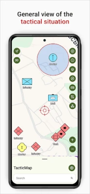
* Map Operations: Download cartographic data for both online and offline use. We offer a wide selection of maps covering various territories and scales.
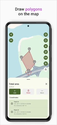
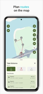
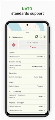
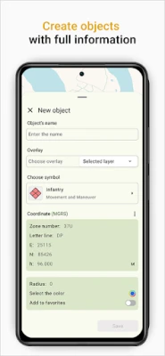
* Creation of Tactical Objects: Our app allows you to create layers and tactical objects according to NATO APP6 standards. You can save and manage critical points and objects on the map.
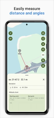
* Support for Coordinate Systems: We support various coordinate systems, including USK2000, WGS84, MGRS, and UTM, enabling you to work with precise data on any terrain.
* Import and Export of Layers: Additional functionality in TacticMap allows you to import and export your layers and objects for easy sharing with other users. Plan and collaborate more efficiently.
Download TacticMap now to access the best tool for working with maps and coordinates. Plan operations, work with precision, and navigate efficiently on the map. Working with geospatial data has never been easier!
* Map Operations: Download cartographic data for both online and offline use. We offer a wide selection of maps covering various territories and scales.
* Creation of Tactical Objects: Our app allows you to create layers and tactical objects according to NATO APP6 standards. You can save and manage critical points and objects on the map.
* Support for Coordinate Systems: We support various coordinate systems, including USK2000, WGS84, MGRS, and UTM, enabling you to work with precise data on any terrain.
* Import and Export of Layers: Additional functionality in TacticMap allows you to import and export your layers and objects for easy sharing with other users. Plan and collaborate more efficiently.
Download TacticMap now to access the best tool for working with maps and coordinates. Plan operations, work with precision, and navigate efficiently on the map. Working with geospatial data has never been easier!
Rate the App
Add Comment & Review
User Reviews
Based on 0 reviews
No reviews added yet.
Comments will not be approved to be posted if they are SPAM, abusive, off-topic, use profanity, contain a personal attack, or promote hate of any kind.


More »

Popular Apps

phpFoxPHPFOX LLC

Moon Chai StoryOlha Dobel

World War Heroes — WW2 PvP FPSAzur Interactive Games Limited

Govee LiteGovee

Build World AdventureExplore city in cube world

Viking Clan: RagnarokKano Games

Vikings: War of ClansPlarium LLC

Submarine Car Diving SimulatorSwim with dolphins & penguins

Asphalt 9: LegendsGameloft SE
Dawn of Zombies: Survival GameRoyal Ark
More »
Editor's Choice

Grim Soul: Dark Survival RPGBrickworks Games Ltd

Craft of Survival - Gladiators101XP LIMITED

Last Shelter: SurvivalLong Tech Network Limited
Dawn of Zombies: Survival GameRoyal Ark

Merge Survival : WastelandStickyHands Inc.

AoD Vikings: Valhalla GameRoboBot Studio
Viking Clan: RagnarokKano Games
Vikings: War of ClansPlarium LLC
Asphalt 9: LegendsGameloft SE

Modern Tanks: War Tank GamesXDEVS LTD