
Latest Version
Update
March 06, 2026
March 06, 2026
Developer
하늘소프트
하늘소프트
Categories
Maps & Navigation
Maps & Navigation
Platforms
Android
Android
Downloads
0
0
License
Free
Free
Package Name
com.hanulsoft.hnsseamap
com.hanulsoft.hnsseamap
Report
Report a Problem
Report a Problem
More About Seamap Standard
Stop switching back and forth between land maps and nautical charts.
Standard Sea Map is an all-in-one marine navigation app that integrates international standard Electronic Navigational Charts (ENC) with familiar land maps. We make every moment of your maritime journey safer and smarter.
🗺️ Key Features
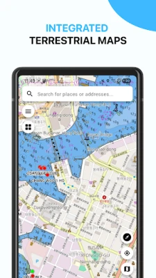
■ Seamless Land & Sea Integration
Track your precise location on the water in relation to the coastline. Navigate with confidence using detailed chart data that meets International Hydrographic Organization (IHO) standards.
■ 🚨 One-Stop Emergency SOS
In an emergency, every second counts. Send optimized rescue data to authorities with a single tap to secure the "Golden Time."
Precise Location Sharing: Provides your current coordinates via GPS in various formats, including DMS (Degrees, Minutes, Seconds), and converts them into a readable physical address.
Visual Situational Report: Automatically merges site photos with server-generated maps at three different zoom levels, allowing rescuers to grasp the situation at a glance.
Emergency Web Link: Generates a dedicated QR code and web link containing the accident type (collision, fire, medical emergency, etc.), enabling rescuers to track your real-time location instantly.
Multi-Channel Sharing: Send the integrated SOS report immediately via MMS or messengers to the Coast Guard, Ministry of Oceans and Fisheries, or your emergency contacts.
■ Powerful Destination Search
Easily find islands, ports, or specific addresses. Locate any destination on the map quickly and accurately.
■ Accurate Location & Address Sharing
Check land addresses (street names/lot numbers) for any point on the map and share your current coordinates with friends and family instantly.
⚓ Smart Navigation Tools
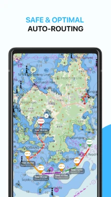
■ Optimized Route Planning
Set your start point, waypoints, and destination. The app recommends the safest and most efficient route based on your vessel's safety depth settings.
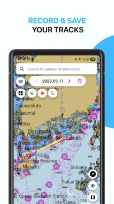
■ Track Logging & Management
Your sailing history is automatically saved by date. Review your past tracks on the map, manage them individually, or delete them as needed.
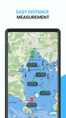
■ Easy Distance Measurement
Quickly measure the distance between multiple points on the map in either meters (m) or Nautical Miles (NM).
💎 Go Further with Premium
Unlock Premium features for professional-grade navigation and enhanced safety!
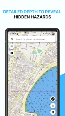
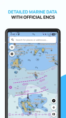
Detailed Bathymetry (Depth Info): Identify hidden hazards like reefs or shallow areas with dense contour lines and precise depth soundings.
Professional Map Settings: Customize your map view with different categories (Base/Standard/Detailed), Day/Night modes, and image formats (PNG/WebP) to suit your navigation style.
Download Standard Sea Map today and explore the open waters with peace of mind.
Wherever your journey takes you, Standard Sea Map is with you for a safe and enjoyable voyage.
🗺️ Key Features
■ Seamless Land & Sea Integration
Track your precise location on the water in relation to the coastline. Navigate with confidence using detailed chart data that meets International Hydrographic Organization (IHO) standards.
■ 🚨 One-Stop Emergency SOS
In an emergency, every second counts. Send optimized rescue data to authorities with a single tap to secure the "Golden Time."
Precise Location Sharing: Provides your current coordinates via GPS in various formats, including DMS (Degrees, Minutes, Seconds), and converts them into a readable physical address.
Visual Situational Report: Automatically merges site photos with server-generated maps at three different zoom levels, allowing rescuers to grasp the situation at a glance.
Emergency Web Link: Generates a dedicated QR code and web link containing the accident type (collision, fire, medical emergency, etc.), enabling rescuers to track your real-time location instantly.
Multi-Channel Sharing: Send the integrated SOS report immediately via MMS or messengers to the Coast Guard, Ministry of Oceans and Fisheries, or your emergency contacts.
■ Powerful Destination Search
Easily find islands, ports, or specific addresses. Locate any destination on the map quickly and accurately.
■ Accurate Location & Address Sharing
Check land addresses (street names/lot numbers) for any point on the map and share your current coordinates with friends and family instantly.
⚓ Smart Navigation Tools
■ Optimized Route Planning
Set your start point, waypoints, and destination. The app recommends the safest and most efficient route based on your vessel's safety depth settings.
■ Track Logging & Management
Your sailing history is automatically saved by date. Review your past tracks on the map, manage them individually, or delete them as needed.
■ Easy Distance Measurement
Quickly measure the distance between multiple points on the map in either meters (m) or Nautical Miles (NM).
💎 Go Further with Premium
Unlock Premium features for professional-grade navigation and enhanced safety!
Detailed Bathymetry (Depth Info): Identify hidden hazards like reefs or shallow areas with dense contour lines and precise depth soundings.
Professional Map Settings: Customize your map view with different categories (Base/Standard/Detailed), Day/Night modes, and image formats (PNG/WebP) to suit your navigation style.
Download Standard Sea Map today and explore the open waters with peace of mind.
Wherever your journey takes you, Standard Sea Map is with you for a safe and enjoyable voyage.
Rate the App
Add Comment & Review
User Reviews
Based on 0 reviews
No reviews added yet.
Comments will not be approved to be posted if they are SPAM, abusive, off-topic, use profanity, contain a personal attack, or promote hate of any kind.


More »

Popular Apps

phpFoxPHPFOX LLC

Moon Chai StoryOlha Dobel

World War Heroes — WW2 PvP FPSAzur Interactive Games Limited

Govee LiteGovee

Build World AdventureExplore city in cube world

Viking Clan: RagnarokKano Games

Vikings: War of ClansPlarium LLC

Asphalt 9: LegendsGameloft SE

Submarine Car Diving SimulatorSwim with dolphins & penguins

Dawn of Zombies: Survival GameRoyal Ark
More »
Editor's Choice

Grim Soul: Dark Survival RPGBrickworks Games Ltd

Craft of Survival - Gladiators101XP LIMITED

Last Shelter: SurvivalLong Tech Network Limited
Dawn of Zombies: Survival GameRoyal Ark

Merge Survival : WastelandStickyHands Inc.

AoD Vikings: Valhalla GameRoboBot Studio
Viking Clan: RagnarokKano Games
Vikings: War of ClansPlarium LLC
Asphalt 9: LegendsGameloft SE

Modern Tanks: War Tank GamesXDEVS LTD