

Latest Version
Update
November 18, 2026
November 18, 2026
Developer
Deve
Deve
Categories
Tools
Tools
Platforms
Android
Android
Downloads
0
0
License
Free
Free
Package Name
net.deve.latlong
net.deve.latlong
Report
Report a Problem
Report a Problem
More About GPS Coordinates & My Location
LatLong finds the GPS coordinates of any place in seconds. Search an address or tap the map to get its latitude and longitude, see your current location with altitude, and use 13 GPS tools for maps, measuring, navigation and the outdoors.
FIND GPS COORDINATES (LAT LONG)
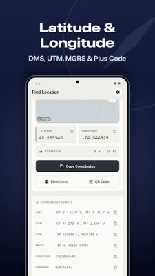
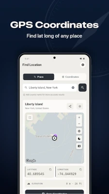
Type an address, city, landmark or place name and LatLong shows the exact latitude and longitude on the map. Enter coordinates to find a point, or tap anywhere on the map to get its coordinates and address (reverse geocoding). Every location comes with its elevation above sea level and seven coordinate formats: Decimal Degrees, DMS (degrees, minutes, seconds), DDM, UTM, MGRS, Plus Code and Geohash. Copy or share your coordinates in one tap, show them as a QR code, or open directions in Google Maps or Waze.
WHERE AM I? MY GPS LOCATION
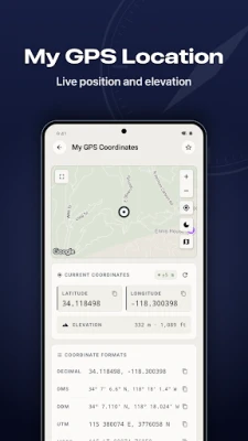
My GPS Coordinates shows your current location live: lat long, GPS accuracy, altitude and the nearest address, in every format. The quick answer to "where am I" when you need to send your position or note a waypoint.
13 GPS TOOLS
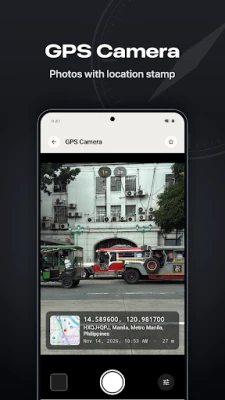
• GPS Camera – take photos with a GPS stamp: coordinates, address, date and time, and a small map on the picture
• Photo Location – see on the map where a photo was taken from its GPS data
• Altimeter – live altitude and elevation, air pressure, climb and descent
• GPS Speedometer – current, average and max speed in km/h, mph or knots, trip distance, moving time, a live speed notification and a speed limit alert that also works in the background
• Navigate to Point – a compass arrow with the distance and bearing to any coordinate
• Sunrise & Sunset – sun and moon times, golden hour, blue hour and moon phase for any place
• Distance Calculator – measure distance on the map point by point
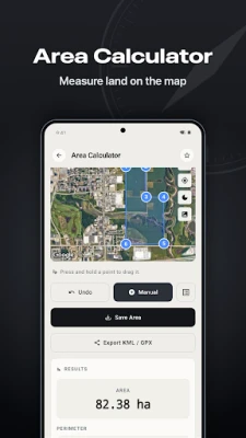
• Area Calculator – measure land area and perimeter of a field, plot or garden on the map
• Coordinate Converter – convert between all seven formats
• Compass – digital compass with true north and magnetic north
• Qibla Compass – Qibla direction and distance to the Kaaba
• Time Zone Finder – the time zone and local time of any point on the map
• My GPS Coordinates – your live position in every format
GPS TRACK RECORDER
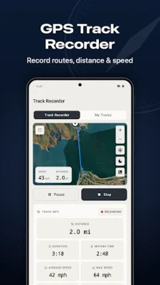
Record your route on a hike, walk, run or bike ride. Recording continues in the background, even with the screen off, and a live notification shows distance, time and speed (a status bar chip on Android 16), with Pause and Resume right in the notification. LatLong draws the GPS track on the map with elevation gain and loss. Export your tracks as GPX or KML files for other map apps.
MY PLACES: FAVORITES, FOLDERS & HISTORY
Save locations to Favorites and sort them into folders with colors, each shown on its own map. Import places from KML and GPX files, and keep your measured distances and land areas to open, rename or export later. Your search history is always one tap away.
SHARE LOCATION
Share coordinates as text, as a map link or as a QR code that any phone camera can scan to open the place on a map.
HOME-SCREEN WIDGETS
• My Location – your coordinates and altitude at a glance
• Sun & Golden Hour – today's sunrise and sunset with a countdown to golden hour
• Moon Phase – today's moon, its illumination and the next full moon
• Track Recorder – start or pause a recording in one tap and see the live distance
EXPLORER CARD
Your lifetime stats on one card: distance recorded, land measured, places saved, GPS photos and your highest point. Unlock 12 milestone badges and share your card.
DESIGNED FOR EVERYDAY USE
• Four simple tabs: Find Location, Tools, Tracks and My Places
• Star your favorite tools to keep them on the Find Location screen
• Full-screen maps with standard, satellite and hybrid layers, in light or dark mode
• Available in 16 languages
WHO USES LATLONG
Hikers, drivers, surveyors who need UTM or MGRS, farmers measuring land, photographers and travelers. From a quick lat long lookup to a full GPS coordinates toolkit, it's all in one app.
Type an address, city, landmark or place name and LatLong shows the exact latitude and longitude on the map. Enter coordinates to find a point, or tap anywhere on the map to get its coordinates and address (reverse geocoding). Every location comes with its elevation above sea level and seven coordinate formats: Decimal Degrees, DMS (degrees, minutes, seconds), DDM, UTM, MGRS, Plus Code and Geohash. Copy or share your coordinates in one tap, show them as a QR code, or open directions in Google Maps or Waze.
WHERE AM I? MY GPS LOCATION
My GPS Coordinates shows your current location live: lat long, GPS accuracy, altitude and the nearest address, in every format. The quick answer to "where am I" when you need to send your position or note a waypoint.
13 GPS TOOLS
• GPS Camera – take photos with a GPS stamp: coordinates, address, date and time, and a small map on the picture
• Photo Location – see on the map where a photo was taken from its GPS data
• Altimeter – live altitude and elevation, air pressure, climb and descent
• GPS Speedometer – current, average and max speed in km/h, mph or knots, trip distance, moving time, a live speed notification and a speed limit alert that also works in the background
• Navigate to Point – a compass arrow with the distance and bearing to any coordinate
• Sunrise & Sunset – sun and moon times, golden hour, blue hour and moon phase for any place
• Distance Calculator – measure distance on the map point by point
• Area Calculator – measure land area and perimeter of a field, plot or garden on the map
• Coordinate Converter – convert between all seven formats
• Compass – digital compass with true north and magnetic north
• Qibla Compass – Qibla direction and distance to the Kaaba
• Time Zone Finder – the time zone and local time of any point on the map
• My GPS Coordinates – your live position in every format
GPS TRACK RECORDER
Record your route on a hike, walk, run or bike ride. Recording continues in the background, even with the screen off, and a live notification shows distance, time and speed (a status bar chip on Android 16), with Pause and Resume right in the notification. LatLong draws the GPS track on the map with elevation gain and loss. Export your tracks as GPX or KML files for other map apps.
MY PLACES: FAVORITES, FOLDERS & HISTORY
Save locations to Favorites and sort them into folders with colors, each shown on its own map. Import places from KML and GPX files, and keep your measured distances and land areas to open, rename or export later. Your search history is always one tap away.
SHARE LOCATION
Share coordinates as text, as a map link or as a QR code that any phone camera can scan to open the place on a map.
HOME-SCREEN WIDGETS
• My Location – your coordinates and altitude at a glance
• Sun & Golden Hour – today's sunrise and sunset with a countdown to golden hour
• Moon Phase – today's moon, its illumination and the next full moon
• Track Recorder – start or pause a recording in one tap and see the live distance
EXPLORER CARD
Your lifetime stats on one card: distance recorded, land measured, places saved, GPS photos and your highest point. Unlock 12 milestone badges and share your card.
DESIGNED FOR EVERYDAY USE
• Four simple tabs: Find Location, Tools, Tracks and My Places
• Star your favorite tools to keep them on the Find Location screen
• Full-screen maps with standard, satellite and hybrid layers, in light or dark mode
• Available in 16 languages
WHO USES LATLONG
Hikers, drivers, surveyors who need UTM or MGRS, farmers measuring land, photographers and travelers. From a quick lat long lookup to a full GPS coordinates toolkit, it's all in one app.
Rate the App
Add Comment & Review
User Reviews
Based on 0 reviews
No reviews added yet.
Comments will not be approved to be posted if they are SPAM, abusive, off-topic, use profanity, contain a personal attack, or promote hate of any kind.










More »

Popular Apps

phpFoxPHPFOX LLC

Moon Chai StoryOlha Dobel

World War Heroes — WW2 PvP FPSAzur Interactive Games Limited

Govee LiteGovee

AvSeaAvionics Electronics Geeks!

Viking Clan: RagnarokKano Games

Vikings: War of ClansPlarium LLC

Build World AdventureExplore city in cube world

Asphalt 9: LegendsGameloft SE
Dawn of Zombies: Survival GameRoyal Ark
More »
Editor's Choice

Grim Soul: Dark Survival RPGBrickworks Games Ltd

Craft of Survival - Gladiators101XP LIMITED

Last Shelter: SurvivalLong Tech Network Limited
Dawn of Zombies: Survival GameRoyal Ark

Merge Survival : WastelandStickyHands Inc.

AoD Vikings: Valhalla GameRoboBot Studio
Viking Clan: RagnarokKano Games
Vikings: War of ClansPlarium LLC
Asphalt 9: LegendsGameloft SE

Modern Tanks: War Tank GamesXDEVS LTD