

Latest Version
Version
5.2.3
5.2.3
Update
November 17, 2026
November 17, 2026
Developer
NKSoft
NKSoft
Categories
Maps & Navigation
Maps & Navigation
Platforms
Android
Android
Downloads
0
0
License
Free
Free
Package Name
com.nksoftware.gpsairnavigator
com.nksoftware.gpsairnavigator
Report
Report a Problem
Report a Problem
More About GPS Air Navigator
GPS Air Navigator is a moving-map air navigation app for VFR pilots: airspace, terrain, weather, routes, and a flight logbook in one clean display, built for phones and tablets, with or without an internet connection.
Follow us on https://www.facebook.com/gpsairnavigator
SEE EVERYTHING AROUND YOU
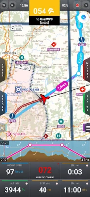
• Real-time GPS moving map with vector and raster charts, in portrait and landscape, on phones and tablets
• Airspace color-coded by class (CTR, TMA, R, P, D, ATZ, RMZ, TMZ...) from OpenAIP and OpenFlightMaps, with tap-for-details and proximity alerts
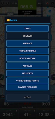
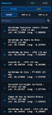
• Layers panel: show or hide airfields, heliports, VFR reporting points (compulsory and optional) and navaids (VOR, VOR/DME, DME, NDB)
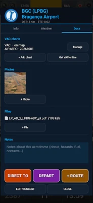
• World database of more than 80,000 airports, heliports and waypoints (runways, frequencies, elevation) from OurAirports, with redesigned runway symbols
• Navigation with True or Magnetic North, and MSL or QFE altitude
ANALOG INSTRUMENTS: THE SACRED SIX
• Airspeed, attitude, altimeter, turn coordinator, heading and vertical speed, drawn on screen and fed by the GPS and your device's sensors
• Docked beside the map on tablets, floating over it on phones
• Two built-in stopwatches
• A navigation aid, not a replacement for the aircraft's instruments
FLIGHT SIMULATOR MODE
• Practice at home: position, track, speed and altitude come from your simulator instead of the GPS
• X-Plane 11 and 12 connect directly; Microsoft Flight Simulator 2020 and 2024 connect through a free helper program on your PC (fs2ff or FS2020 to NMEA), over the same Wi-Fi
• Rehearse routes, learn the app, and plan a flight before flying it for real; always marked "not for real navigation"
TERRAIN AND WEATHER
• Terrain elevation profile with real-time collision warning
• Route GRAMET: clouds, wind and terrain along your planned route
• METAR, TAF and NOTAM consultation integrated
PLAN AND FLY
• Create and manage routes with multiple legs, ETE/ETA and a route cruise profile
• Create and edit your own waypoints, runways and frequencies; import/export waypoints between devices
• Fly To: waypoint, coordinates, bearing and distance, or reverse the current route
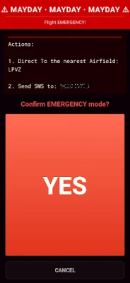
• MAYDAY button: opens your SMS app with the current GPS coordinates and a Google Maps link, and activates the route to the nearest aerodrome
LOG AND SHARE
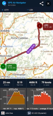
• Automatic flight logbook with aircraft and pilots, and flight statistics (distance, altitude, speed)
• Real-time track recording, saved to GPX for offline processing
• Share flight screenshots by email, WhatsApp, and more
MAPS, EVEN OFFLINE
• Download maps by country or region and keep navigating with no signal
• Offline vector maps from OpenAndroMaps covering Europe, the Americas, Africa, Asia, Oceania and Russia
• USA Sectional VFR Charts (FAA VFR Raster Charts)
• WAC and REA Charts from Brazil (DECEA-Brazil)
• OpenFlightMaps charts for many European countries, including Germany, Austria, Switzerland, Belgium, the Netherlands, Poland, the Czech Republic, Croatia, Slovenia, Hungary, Romania, Bulgaria, Denmark and Sweden
• Daily airspace updates for Portugal (FuaFlex, [www.cavok.pt](https://www.cavok.pt))
Available in English, Portuguese, Spanish, French, Italian and Czech. One license covers all your Android devices.
After installation, you can try the app with these limitations:
• You can save only two user waypoints
• The app closes after 20 minutes of use
If you like GPS Air Navigator, get an annual subscription or a lifetime license inside the app to use it without limitations.
Not a substitute for official aeronautical charts and publications. The pilot in command is always responsible for flight safety.
Enjoy GPS Air Navigator! Fly safe.
SEE EVERYTHING AROUND YOU
• Real-time GPS moving map with vector and raster charts, in portrait and landscape, on phones and tablets
• Airspace color-coded by class (CTR, TMA, R, P, D, ATZ, RMZ, TMZ...) from OpenAIP and OpenFlightMaps, with tap-for-details and proximity alerts
• Layers panel: show or hide airfields, heliports, VFR reporting points (compulsory and optional) and navaids (VOR, VOR/DME, DME, NDB)
• World database of more than 80,000 airports, heliports and waypoints (runways, frequencies, elevation) from OurAirports, with redesigned runway symbols
• Navigation with True or Magnetic North, and MSL or QFE altitude
ANALOG INSTRUMENTS: THE SACRED SIX
• Airspeed, attitude, altimeter, turn coordinator, heading and vertical speed, drawn on screen and fed by the GPS and your device's sensors
• Docked beside the map on tablets, floating over it on phones
• Two built-in stopwatches
• A navigation aid, not a replacement for the aircraft's instruments
FLIGHT SIMULATOR MODE
• Practice at home: position, track, speed and altitude come from your simulator instead of the GPS
• X-Plane 11 and 12 connect directly; Microsoft Flight Simulator 2020 and 2024 connect through a free helper program on your PC (fs2ff or FS2020 to NMEA), over the same Wi-Fi
• Rehearse routes, learn the app, and plan a flight before flying it for real; always marked "not for real navigation"
TERRAIN AND WEATHER
• Terrain elevation profile with real-time collision warning
• Route GRAMET: clouds, wind and terrain along your planned route
• METAR, TAF and NOTAM consultation integrated
PLAN AND FLY
• Create and manage routes with multiple legs, ETE/ETA and a route cruise profile
• Create and edit your own waypoints, runways and frequencies; import/export waypoints between devices
• Fly To: waypoint, coordinates, bearing and distance, or reverse the current route
• MAYDAY button: opens your SMS app with the current GPS coordinates and a Google Maps link, and activates the route to the nearest aerodrome
LOG AND SHARE
• Automatic flight logbook with aircraft and pilots, and flight statistics (distance, altitude, speed)
• Real-time track recording, saved to GPX for offline processing
• Share flight screenshots by email, WhatsApp, and more
MAPS, EVEN OFFLINE
• Download maps by country or region and keep navigating with no signal
• Offline vector maps from OpenAndroMaps covering Europe, the Americas, Africa, Asia, Oceania and Russia
• USA Sectional VFR Charts (FAA VFR Raster Charts)
• WAC and REA Charts from Brazil (DECEA-Brazil)
• OpenFlightMaps charts for many European countries, including Germany, Austria, Switzerland, Belgium, the Netherlands, Poland, the Czech Republic, Croatia, Slovenia, Hungary, Romania, Bulgaria, Denmark and Sweden
• Daily airspace updates for Portugal (FuaFlex, [www.cavok.pt](https://www.cavok.pt))
Available in English, Portuguese, Spanish, French, Italian and Czech. One license covers all your Android devices.
After installation, you can try the app with these limitations:
• You can save only two user waypoints
• The app closes after 20 minutes of use
If you like GPS Air Navigator, get an annual subscription or a lifetime license inside the app to use it without limitations.
Not a substitute for official aeronautical charts and publications. The pilot in command is always responsible for flight safety.
Enjoy GPS Air Navigator! Fly safe.
Rate the App
Add Comment & Review
User Reviews
Based on 0 reviews
No reviews added yet.
Comments will not be approved to be posted if they are SPAM, abusive, off-topic, use profanity, contain a personal attack, or promote hate of any kind.















More »

Popular Apps

phpFoxPHPFOX LLC

Moon Chai StoryOlha Dobel

World War Heroes — WW2 PvP FPSAzur Interactive Games Limited

Govee LiteGovee

AvSeaAvionics Electronics Geeks!

Viking Clan: RagnarokKano Games

Vikings: War of ClansPlarium LLC

Build World AdventureExplore city in cube world

Asphalt 9: LegendsGameloft SE

Dawn of Zombies: Survival GameRoyal Ark
More »
Editor's Choice

Grim Soul: Dark Survival RPGBrickworks Games Ltd

Craft of Survival - Gladiators101XP LIMITED

Last Shelter: SurvivalLong Tech Network Limited
Dawn of Zombies: Survival GameRoyal Ark

Merge Survival : WastelandStickyHands Inc.

AoD Vikings: Valhalla GameRoboBot Studio
Viking Clan: RagnarokKano Games
Vikings: War of ClansPlarium LLC
Asphalt 9: LegendsGameloft SE

Modern Tanks: War Tank GamesXDEVS LTD