

Latest Version
Version
10.0.200
10.0.200
Update
November 16, 2026
November 16, 2026
Developer
Military App
Military App
Categories
Maps & Navigation
Maps & Navigation
Platforms
Android
Android
Downloads
0
0
License
$9.49
$9.49
Package Name
com.alpinquest.app
com.alpinquest.app
Report
Report a Problem
Report a Problem
More About Alpin Quest PRO – Outdoor GPS
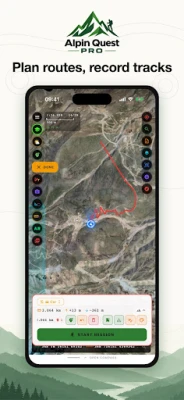
Alpin Quest PRO is a professional GPS and field GIS app built for soldiers, geologists, surveyors, foresters, mountaineers, hunters and off-road drivers. Load your paper map onto your phone and see exactly where you are in the field, even without signal.
MAPS
Satellite, topographic, hybrid and road maps; contour lines and hillshade
Names of peaks, passes, springs and streams on the map
MGRS and UTM km grid, map locked to a fixed scale (such as 1:25,000)
Instant terrain type, slope and elevation
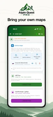
BRING YOUR OWN MAPS
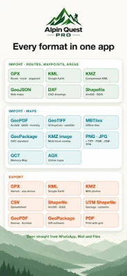
GeoPDF (ArcGIS, QGIS, forest stand maps), GeoTIFF, MBTiles, GeoPackage
KMZ image overlays and large multi-level KMZ files
Shapefile (ZIP), KML/KMZ vector, Memory-Map (.qct), AlpineQuest AQX
Image + world file: PNG, JPG, TIFF with PGW, JGW, TFW
Hide white paper margins, set opacity and layer order
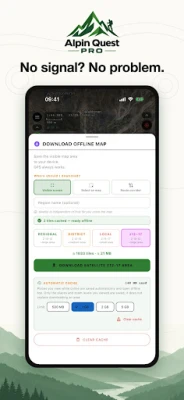
OFFLINE
Download the visible screen, an area you select or a route corridor
Places you view are cached automatically
Full functionality without a cell network
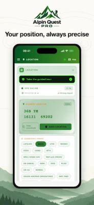
COORDINATE SYSTEMS (19)
MGRS, UTM, USNG, WGS84, DMS, DDM, Plus Code, QTH
ED50, CK-42 / SK-42, BNG (OSGB), India Grid and NSF LCC, Lambert Maroc
Gauss-Krüger Argentina, Arc 1960, RSO Malaya, SAD69
Your position in every system at once, copied with one tap
Magnetic declination (NOAA WMM), true, magnetic and grid north; degrees or mils
WAYPOINTS
Unlimited waypoints, photo waypoints, folders and search
Manual entry by coordinate, averaged measurement for precision
Live distance, bearing and ETA to your target
Choose label position: below, above, right or left
ROUTES AND TRACKS
Draw routes point by point, by panning or with your finger
Auto-routing along roads for walking, driving and hiking
Elevation profile with climb and descent
Continuous background track recording with speed and distance stats
Off-route warning
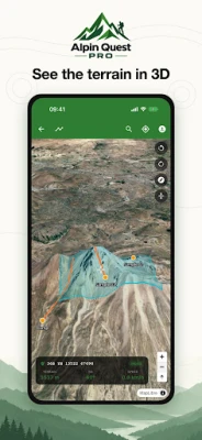
3D TERRAIN
Check your routes and areas on real elevation
AREAS AND DRAWING
Polygons, circles and rectangles with area and perimeter
Move on the map, edit vertices, split into parts and sectors
Rock patterns for geology, freehand drawing and text for briefings
PROJECTS (GIS) AND TEAM MODE
Keep all waypoints, routes, areas and maps of one job in a single project
Export as KML, KMZ, GPX, Shapefile and UTM Shapefile
Team Mode: share your project with your team and see everyone live on the map
AR AND WATCHES
Names of nearby peaks and passes in the camera view (AR)
Direction to your target on Apple Watch, Wear OS and Garmin watches
FIELD TOOLS
Proximity alert as you approach a target
Coordinate stamp on photos
Weather: hourly and 7-day forecast, sunrise, sunset, moonrise and moon phase
Battery-friendly track recording profiles
Zoom with the volume keys (works with gloves)
Printable PDF maps with grid (A4, A3)
Step-by-step guided tour
FILE SHARING
Import: GPX, KML, KMZ, GeoJSON, DXF, Shapefile
Export: GPX, KML, KMZ, CSV, Shapefile, GeoPDF, GeoPackage
Open files straight from WhatsApp, Mail and Files
31 LANGUAGES English, Turkish, German, French, Spanish, Italian, Portuguese, Dutch, Norwegian, Russian, Ukrainian, Bulgarian, Croatian, Slovak, Slovenian, Lithuanian, Romanian, Arabic, Persian, Azerbaijani, Kazakh, Uzbek, Hindi, Chinese, Japanese, Korean, Indonesian, Malay, Thai, Filipino, Afrikaans.
Satellite, topographic, hybrid and road maps; contour lines and hillshade
Names of peaks, passes, springs and streams on the map
MGRS and UTM km grid, map locked to a fixed scale (such as 1:25,000)
Instant terrain type, slope and elevation
BRING YOUR OWN MAPS
GeoPDF (ArcGIS, QGIS, forest stand maps), GeoTIFF, MBTiles, GeoPackage
KMZ image overlays and large multi-level KMZ files
Shapefile (ZIP), KML/KMZ vector, Memory-Map (.qct), AlpineQuest AQX
Image + world file: PNG, JPG, TIFF with PGW, JGW, TFW
Hide white paper margins, set opacity and layer order
OFFLINE
Download the visible screen, an area you select or a route corridor
Places you view are cached automatically
Full functionality without a cell network
COORDINATE SYSTEMS (19)
MGRS, UTM, USNG, WGS84, DMS, DDM, Plus Code, QTH
ED50, CK-42 / SK-42, BNG (OSGB), India Grid and NSF LCC, Lambert Maroc
Gauss-Krüger Argentina, Arc 1960, RSO Malaya, SAD69
Your position in every system at once, copied with one tap
Magnetic declination (NOAA WMM), true, magnetic and grid north; degrees or mils
WAYPOINTS
Unlimited waypoints, photo waypoints, folders and search
Manual entry by coordinate, averaged measurement for precision
Live distance, bearing and ETA to your target
Choose label position: below, above, right or left
ROUTES AND TRACKS
Draw routes point by point, by panning or with your finger
Auto-routing along roads for walking, driving and hiking
Elevation profile with climb and descent
Continuous background track recording with speed and distance stats
Off-route warning
3D TERRAIN
Check your routes and areas on real elevation
AREAS AND DRAWING
Polygons, circles and rectangles with area and perimeter
Move on the map, edit vertices, split into parts and sectors
Rock patterns for geology, freehand drawing and text for briefings
PROJECTS (GIS) AND TEAM MODE
Keep all waypoints, routes, areas and maps of one job in a single project
Export as KML, KMZ, GPX, Shapefile and UTM Shapefile
Team Mode: share your project with your team and see everyone live on the map
AR AND WATCHES
Names of nearby peaks and passes in the camera view (AR)
Direction to your target on Apple Watch, Wear OS and Garmin watches
FIELD TOOLS
Proximity alert as you approach a target
Coordinate stamp on photos
Weather: hourly and 7-day forecast, sunrise, sunset, moonrise and moon phase
Battery-friendly track recording profiles
Zoom with the volume keys (works with gloves)
Printable PDF maps with grid (A4, A3)
Step-by-step guided tour
FILE SHARING
Import: GPX, KML, KMZ, GeoJSON, DXF, Shapefile
Export: GPX, KML, KMZ, CSV, Shapefile, GeoPDF, GeoPackage
Open files straight from WhatsApp, Mail and Files
31 LANGUAGES English, Turkish, German, French, Spanish, Italian, Portuguese, Dutch, Norwegian, Russian, Ukrainian, Bulgarian, Croatian, Slovak, Slovenian, Lithuanian, Romanian, Arabic, Persian, Azerbaijani, Kazakh, Uzbek, Hindi, Chinese, Japanese, Korean, Indonesian, Malay, Thai, Filipino, Afrikaans.
Rate the App
Add Comment & Review
User Reviews
Based on 0 reviews
No reviews added yet.
Comments will not be approved to be posted if they are SPAM, abusive, off-topic, use profanity, contain a personal attack, or promote hate of any kind.













More »

Popular Apps

phpFoxPHPFOX LLC

Moon Chai StoryOlha Dobel

World War Heroes — WW2 PvP FPSAzur Interactive Games Limited

Govee LiteGovee

AvSeaAvionics Electronics Geeks!

Viking Clan: RagnarokKano Games

Vikings: War of ClansPlarium LLC

Build World AdventureExplore city in cube world

Asphalt 9: LegendsGameloft SE
Dawn of Zombies: Survival GameRoyal Ark
More »
Editor's Choice

Grim Soul: Dark Survival RPGBrickworks Games Ltd

Craft of Survival - Gladiators101XP LIMITED

Last Shelter: SurvivalLong Tech Network Limited
Dawn of Zombies: Survival GameRoyal Ark

Merge Survival : WastelandStickyHands Inc.

AoD Vikings: Valhalla GameRoboBot Studio
Viking Clan: RagnarokKano Games
Vikings: War of ClansPlarium LLC
Asphalt 9: LegendsGameloft SE

Modern Tanks: War Tank GamesXDEVS LTD