

Latest Version
Version
3.4.1
3.4.1
Update
June 23, 2025
June 23, 2025
Developer
Backroad Mapbooks
Backroad Mapbooks
Categories
Maps & Navigation
Maps & Navigation
Platforms
Android
Android
Downloads
0
0
License
Free
Free
Package Name
com.backroadmapbooks.backroadmapbookscanada
com.backroadmapbooks.backroadmapbookscanada
Report
Report a Problem
Report a Problem
More About BRMB Maps by Backroad Maps
Canada’s #1 App for Hunting, Fishing, Camping & Outdoor Adventure
Explore Canada’s outdoors with confidence using BRMB Maps, the most detailed and trusted GPS navigation app for the backcountry. Built from the award-winning Backroad Mapbooks series, BRMB Maps combines detailed topographic maps with over 900,000 searchable Points of Interest across every province and territory.
Whether you're into fishing, camping, hiking, hunting, paddling, ATVing, snowmobiling, or wildlife viewing, BRMB Maps has everything you need to plan, navigate, and explore – online or offline.
🧭 Key Features
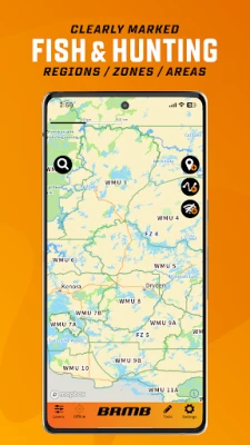
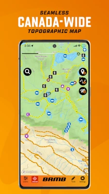
Topographic GPS Maps: View relief shading, contour lines, backroads, parks, and geographic features
Current Location Tracking: Use your phone’s GPS to navigate in real time
Cross-Device Access: Use on smartphone, tablet, and desktop with a single account
Canada-Wide Basemap: Includes a seamless basemap from Backroad Maps across Canada
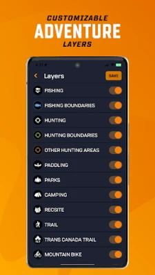
Custom Adventure Layers: Enable fishing, hunting, trails, paddling, Crown land & more
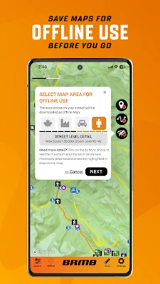
Offline Maps: Download maps and all POI details for off-grid navigation
Satellite Imagery: Overlay roads, trails, and features on high-res satellite maps
Trip Recording & Custom Waypoints: Track routes, mark campsites, and save locations
Printable Custom Maps: Create and print stunning maps from brmbmaps.com
🔍 Explore Over 150,000 Adventure Sites
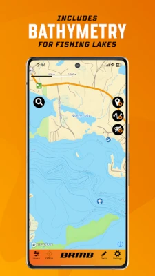
Fishing 🎣
22,000+ lakes, rivers, creeks & ocean fishing areas
Bathymetry (lake & ocean depths), fish species, stocked lakes, boat launches & marinas
Zone boundaries & regulation links
Hunting 🦌
3,500+ hunting areas (WMUs/WMZs/GMAs, species-specific zones)
Species details, boundaries & regulation info
Crown land access & private land overlays
Camping & Parks
20,000 national, provincial, regional, urban, conservation and natural parks
Campsites, picnic areas, backcountry campsites, backcountry huts & cabins
Private campgrounds, resorts & lodges, amenities & services
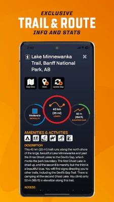
Hiking, Biking & Horseback Trails
130,000+ km of multi-use trails with trailheads, difficulty ratings, distance & elevation gain
Includes hiking, mountain biking, cycling, horseback riding, backpacking, and multi-use
Separate Trans-Canada Trail layer with trailheads, pavilions and alternate routes
Paddling (Canoeing & Kayaking)
107,000+ km of routes with access points, difficulty ratings, distance & grading
Features lake circuits, river and ocean paddling routes, whitewater & more
Paddling routes include portages with distances, campsites, put-ins & take-outs
ATV, OHV, Off-Road and Overland Routes
160,000+ km of trails and routes with staging areas, difficulty ratings & distance
Features ATV/OHV, dirt biking, and overlanding route options
Plus 3,000,000+ km of Roads and 160,000+ km of Logging Roads to explore
Snowmobiling
150,000+ km of trails and routes with staging areas, difficulty ratings & distance
Features federation & club-maintained trails, plus backcountry routes
Clubhouses, warming huts & shelters, side trails and more
Winter Recreation
9,500+ km of ski & snowshoe trails for cross-country, Nordic, backcountry & downhill skiing
2,100+ trailheads, Nordic areas & ski centres
Trails features difficulty ratings, distance, elevation gain & ski area amenities
Wildlife Viewing & Nature
1,800+ sites for birdwatching & wildlife viewing
Features birding sites, fish hatcheries & spawning areas, marine life, small animals & large mammals
Bird viewing & scenic lookouts, trailheads & wildlife centres
Attractions & Unique Sites
20,000+ points, including roadside and backcountry attractions
Features big trees, caves, waterfalls, hot springs, lighthouses, beaches, museums and scenic areas
Commercial sites include hours, location and contact information
Why BRMB Maps?
Unlike other GPS apps, BRMB Maps is built specifically for Canadian terrain and adventure types, with unmatched detail, local insights, and recreation-focused layers. Trusted by search & rescue teams, guides, hunters, anglers and explorers for over 30 years.
Whether you're into fishing, camping, hiking, hunting, paddling, ATVing, snowmobiling, or wildlife viewing, BRMB Maps has everything you need to plan, navigate, and explore – online or offline.
🧭 Key Features
Topographic GPS Maps: View relief shading, contour lines, backroads, parks, and geographic features
Current Location Tracking: Use your phone’s GPS to navigate in real time
Cross-Device Access: Use on smartphone, tablet, and desktop with a single account
Canada-Wide Basemap: Includes a seamless basemap from Backroad Maps across Canada
Custom Adventure Layers: Enable fishing, hunting, trails, paddling, Crown land & more
Offline Maps: Download maps and all POI details for off-grid navigation
Satellite Imagery: Overlay roads, trails, and features on high-res satellite maps
Trip Recording & Custom Waypoints: Track routes, mark campsites, and save locations
Printable Custom Maps: Create and print stunning maps from brmbmaps.com
🔍 Explore Over 150,000 Adventure Sites
Fishing 🎣
22,000+ lakes, rivers, creeks & ocean fishing areas
Bathymetry (lake & ocean depths), fish species, stocked lakes, boat launches & marinas
Zone boundaries & regulation links
Hunting 🦌
3,500+ hunting areas (WMUs/WMZs/GMAs, species-specific zones)
Species details, boundaries & regulation info
Crown land access & private land overlays
Camping & Parks
20,000 national, provincial, regional, urban, conservation and natural parks
Campsites, picnic areas, backcountry campsites, backcountry huts & cabins
Private campgrounds, resorts & lodges, amenities & services
Hiking, Biking & Horseback Trails
130,000+ km of multi-use trails with trailheads, difficulty ratings, distance & elevation gain
Includes hiking, mountain biking, cycling, horseback riding, backpacking, and multi-use
Separate Trans-Canada Trail layer with trailheads, pavilions and alternate routes
Paddling (Canoeing & Kayaking)
107,000+ km of routes with access points, difficulty ratings, distance & grading
Features lake circuits, river and ocean paddling routes, whitewater & more
Paddling routes include portages with distances, campsites, put-ins & take-outs
ATV, OHV, Off-Road and Overland Routes
160,000+ km of trails and routes with staging areas, difficulty ratings & distance
Features ATV/OHV, dirt biking, and overlanding route options
Plus 3,000,000+ km of Roads and 160,000+ km of Logging Roads to explore
Snowmobiling
150,000+ km of trails and routes with staging areas, difficulty ratings & distance
Features federation & club-maintained trails, plus backcountry routes
Clubhouses, warming huts & shelters, side trails and more
Winter Recreation
9,500+ km of ski & snowshoe trails for cross-country, Nordic, backcountry & downhill skiing
2,100+ trailheads, Nordic areas & ski centres
Trails features difficulty ratings, distance, elevation gain & ski area amenities
Wildlife Viewing & Nature
1,800+ sites for birdwatching & wildlife viewing
Features birding sites, fish hatcheries & spawning areas, marine life, small animals & large mammals
Bird viewing & scenic lookouts, trailheads & wildlife centres
Attractions & Unique Sites
20,000+ points, including roadside and backcountry attractions
Features big trees, caves, waterfalls, hot springs, lighthouses, beaches, museums and scenic areas
Commercial sites include hours, location and contact information
Why BRMB Maps?
Unlike other GPS apps, BRMB Maps is built specifically for Canadian terrain and adventure types, with unmatched detail, local insights, and recreation-focused layers. Trusted by search & rescue teams, guides, hunters, anglers and explorers for over 30 years.
Rate the App
Add Comment & Review
User Reviews
Based on 0 reviews
No reviews added yet.
Comments will not be approved to be posted if they are SPAM, abusive, off-topic, use profanity, contain a personal attack, or promote hate of any kind.


More »

Popular Apps

phpFoxPHPFOX LLC

Moon Chai StoryOlha Dobel

World War Heroes — WW2 PvP FPSAzur Interactive Games Limited

Govee LiteGovee

Build World AdventureExplore city in cube world

Viking Clan: RagnarokKano Games

Vikings: War of ClansPlarium LLC

Submarine Car Diving SimulatorSwim with dolphins & penguins

Asphalt 9: LegendsGameloft SE

Dawn of Zombies: Survival GameRoyal Ark
More »
Editor's Choice

Grim Soul: Dark Survival RPGBrickworks Games Ltd

Craft of Survival - Gladiators101XP LIMITED

Last Shelter: SurvivalLong Tech Network Limited
Dawn of Zombies: Survival GameRoyal Ark

Merge Survival : WastelandStickyHands Inc.

AoD Vikings: Valhalla GameRoboBot Studio
Viking Clan: RagnarokKano Games
Vikings: War of ClansPlarium LLC
Asphalt 9: LegendsGameloft SE

Modern Tanks: War Tank GamesXDEVS LTD