


Latest Version
Version
1.2.9
1.2.9
Update
May 02, 2025
May 02, 2025
Developer
Map of Forest Service lands
Map of Forest Service lands
Categories
Travel & Local
Travel & Local
Platforms
iOS
iOS
File Size
225.5 MB
225.5 MB
Downloads
0
0
License
Free
Free
Report
Report a Problem
Report a Problem
More About Visitor Map
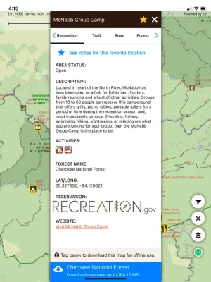
Explore the great outdoors by visiting America’s backyard -- 193 million acres of national forests and grasslands. Find your perfect spot on these expansive lands that include more than 4,300 campgrounds and 158,000 miles of trails, including 31,900 miles on pristine wilderness areas.
Discover our rich cultural heritage at such destinations as Chimney Rock National Monument. Step back into time by stepping on tracks left 150 million years ago by dinosaurs at the Picket Wire Trail in southeast Colorado, where you also can see Native American rock art, ruins from the Dolores Mission and Cemetery and the old Rourke cattle ranch.
These lands also play host to more than 6,000 miles of wild and scenic rivers that offer leisurely rides passed awe-inspiring scenery or breathtaking rollercoaster-like rides down rapids. We are your year-round destination, including skiing on one of the 122 ski areas in the winter, photographing the bursting colors of wildflowers, cooking s’mores around the campfire in the summer or watching leaves change colors in the fall.
Notable app. features include:
* accessible recreation locations
* simplified and streamlined map interface
* national-level search capabilities
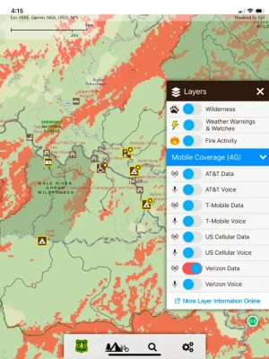
* wildfire and weather warnings/watches
* easily share the map through email or on social networks
These lands also play host to more than 6,000 miles of wild and scenic rivers that offer leisurely rides passed awe-inspiring scenery or breathtaking rollercoaster-like rides down rapids. We are your year-round destination, including skiing on one of the 122 ski areas in the winter, photographing the bursting colors of wildflowers, cooking s’mores around the campfire in the summer or watching leaves change colors in the fall.
Notable app. features include:
* accessible recreation locations
* simplified and streamlined map interface
* national-level search capabilities
* wildfire and weather warnings/watches
* easily share the map through email or on social networks
Rate the App
Add Comment & Review
User Reviews
Based on 0 reviews
No reviews added yet.
Comments will not be approved to be posted if they are SPAM, abusive, off-topic, use profanity, contain a personal attack, or promote hate of any kind.


More »

Popular Apps

phpFoxPHPFOX LLC

Moon Chai StoryOlha Dobel

World War Heroes — WW2 PvP FPSAzur Interactive Games Limited

Govee LiteGovee

Build World AdventureExplore city in cube world

Viking Clan: RagnarokKano Games

Vikings: War of ClansPlarium LLC

Submarine Car Diving SimulatorSwim with dolphins & penguins

Asphalt 9: LegendsGameloft SE

Modern Tanks: War Tank GamesXDEVS LTD
More »
Editor's Choice

Grim Soul: Dark Survival RPGBrickworks Games Ltd

Craft of Survival - Gladiators101XP LIMITED

Last Shelter: SurvivalLong Tech Network Limited

Dawn of Zombies: Survival GameRoyal Ark

Merge Survival : WastelandStickyHands Inc.

AoD Vikings: Valhalla GameRoboBot Studio
Viking Clan: RagnarokKano Games
Vikings: War of ClansPlarium LLC
Asphalt 9: LegendsGameloft SE
Modern Tanks: War Tank GamesXDEVS LTD