Latest Version
Update
November 12, 2025
November 12, 2025
Developer
AppLook Studio
AppLook Studio
Categories
Lifestyle
Lifestyle
Platforms
Android
Android
Downloads
0
0
License
Free
Free
Package Name
com.applook.starlinktracker
com.applook.starlinktracker
Report
Report a Problem
Report a Problem
More About Starlink and ISS Tracker
Discover the real-time location of 5G satellites such as Starlink as they orbit above you. This app allows you to visualize Starlink satellites around Earth in motion, showing how they move and when they become visible from your location. With a live satellite scanner interface, you can track thousands of active satellites that are continuously providing global connectivity.
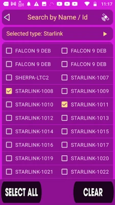
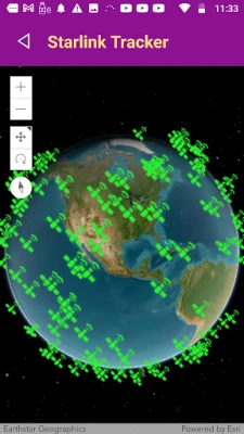
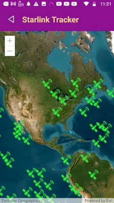
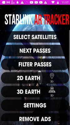
View the Starlink satellites surrounding your location on a 2D radar view, a 3D interactive world map, or a global 2D map with orbital paths. With more than 1800 satellites orbiting at roughly 320 miles (550 km) altitude — and many more scheduled for launch — this network is expanding every month. Follow the passes of each satellite in real time and see how the constellation shifts across the sky.
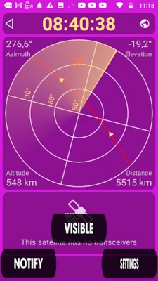
Use the radar view to identify the nearest satellite passing over your exact location. Press the visibility tool to check the elevation angle: if the satellite is above 35 degrees, the Starlink satellite has a strong line of sight and could be within communication-ready range. This gives you a practical and clear way to understand your connection potential based on satellite passes.
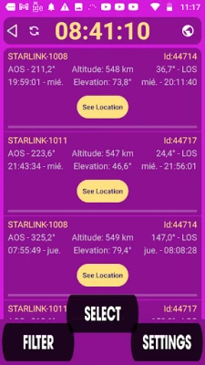
It does not matter whether it is day or night — satellites are always active. The app will show when they will be visible in your location, including peak visibility times and upcoming passes. You can also explore how the Starlink network routes coverage around the planet, observe density over populated areas, and see how satellites coordinate to provide seamless global service.
How does it work?
Simply hold your device and move around. The app updates the directional radar to show where the nearest Starlink satellites are in the sky relative to your location. Watch their motion and orbit direction. Track the passes of multiple satellites and understand how the constellation shifts minute by minute.
Features:
• Real-time Starlink satellite tracking
• 2D radar view showing satellites near your location
• 3D Earth globe visualization with orbital paths
• Global 2D map with objective satellite location overview
• Nearest satellite detection and elevation angle information
• Visibility prediction and passes timeline
• Simple and intuitive interface
Whether you are a skywatcher, a satellite enthusiast, a tech explorer, or simply curious about the invisible infrastructure powering global connectivity, this app brings the Starlink satellites closer to your awareness.
Download now and explore the sky above your location like never before.
Use the radar view to identify the nearest satellite passing over your exact location. Press the visibility tool to check the elevation angle: if the satellite is above 35 degrees, the Starlink satellite has a strong line of sight and could be within communication-ready range. This gives you a practical and clear way to understand your connection potential based on satellite passes.
It does not matter whether it is day or night — satellites are always active. The app will show when they will be visible in your location, including peak visibility times and upcoming passes. You can also explore how the Starlink network routes coverage around the planet, observe density over populated areas, and see how satellites coordinate to provide seamless global service.
How does it work?
Simply hold your device and move around. The app updates the directional radar to show where the nearest Starlink satellites are in the sky relative to your location. Watch their motion and orbit direction. Track the passes of multiple satellites and understand how the constellation shifts minute by minute.
Features:
• Real-time Starlink satellite tracking
• 2D radar view showing satellites near your location
• 3D Earth globe visualization with orbital paths
• Global 2D map with objective satellite location overview
• Nearest satellite detection and elevation angle information
• Visibility prediction and passes timeline
• Simple and intuitive interface
Whether you are a skywatcher, a satellite enthusiast, a tech explorer, or simply curious about the invisible infrastructure powering global connectivity, this app brings the Starlink satellites closer to your awareness.
Download now and explore the sky above your location like never before.
Rate the App
Add Comment & Review
User Reviews
Based on 0 reviews
No reviews added yet.
Comments will not be approved to be posted if they are SPAM, abusive, off-topic, use profanity, contain a personal attack, or promote hate of any kind.


More »

Popular Apps

phpFoxPHPFOX LLC

Moon Chai StoryOlha Dobel

World War Heroes — WW2 PvP FPSAzur Interactive Games Limited

Govee LiteGovee

Build World AdventureExplore city in cube world

Viking Clan: RagnarokKano Games

Vikings: War of ClansPlarium LLC

Asphalt 9: LegendsGameloft SE

Submarine Car Diving SimulatorSwim with dolphins & penguins

Dawn of Zombies: Survival GameRoyal Ark
More »
Editor's Choice

Grim Soul: Dark Survival RPGBrickworks Games Ltd

Craft of Survival - Gladiators101XP LIMITED

Last Shelter: SurvivalLong Tech Network Limited
Dawn of Zombies: Survival GameRoyal Ark

Merge Survival : WastelandStickyHands Inc.

AoD Vikings: Valhalla GameRoboBot Studio
Viking Clan: RagnarokKano Games
Vikings: War of ClansPlarium LLC
Asphalt 9: LegendsGameloft SE

Modern Tanks: War Tank GamesXDEVS LTD