

Latest Version
Update
November 04, 2026
November 04, 2026
Developer
Sospi01
Sospi01
Categories
Sports Apps
Sports Apps
Platforms
Android
Android
Downloads
0
0
License
Free
Free
Package Name
com.sospedra.skiinfo
com.sospedra.skiinfo
Report
Report a Problem
Report a Problem
More About Ski Info: Piste Maps & Snow
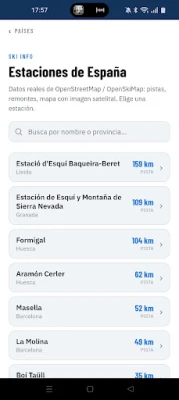
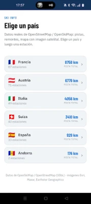
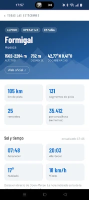
Ski Info puts the piste map of 1,409 ski resorts in 45 countries in your pocket: the Alps, the Pyrenees, North America, Japan, Scandinavia and more. Every resort comes with a 7-day snow forecast and the real gradient of every run.
EVERY RUN, MEASURED
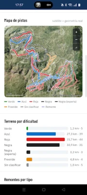
• Interactive piste map over satellite imagery
• Colour the runs by difficulty or by their real slope
• Tap any run to see its elevation profile; slide your finger along it to see the altitude and gradient at each point
• The steepest pitch of every run, right next to its colour
• Where am I: your position on the piste map and the run you're on
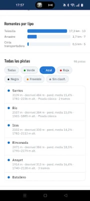
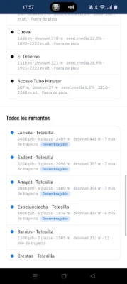
• Lifts by type, with capacity, ride time and whether they have a bubble or heated seats
• Restaurants, bars, first aid and rental shops on the map
SNOW FORECAST
• 7-day snowfall forecast at summit altitude for every resort
• Where it will snow most this week: a ranking by region, updated every day
• Save your favourite resorts and see their snow forecast as soon as you open the app
RANKINGS AND GUIDES
• The biggest ski resorts in the world, the Alps and North America
• The highest resorts and the ones with the most vertical
• The best resorts for beginners
• The steepest and longest runs
• Ski resorts near your city
PLAN YOUR DAY
• Directions to the resort's base area
• Share a resort or its piste map in one tap
• The resorts closest to you
Free, and no account needed. Available in English, Spanish, French, German, Italian, Dutch and Polish.
WHERE THE DATA COMES FROM
Runs and lifts come from OpenStreetMap and OpenSkiMap (ODbL licence), mapped by a worldwide community of volunteers. Gradients are computed from an elevation model. Weather and snow forecasts come from Open-Meteo, and satellite imagery from Esri, Maxar and Earthstar Geographics. Some resorts are mapped in more detail than others, and each resort page shows how complete its data is.
Also on the web: skiinfoapp.com
• Interactive piste map over satellite imagery
• Colour the runs by difficulty or by their real slope
• Tap any run to see its elevation profile; slide your finger along it to see the altitude and gradient at each point
• The steepest pitch of every run, right next to its colour
• Where am I: your position on the piste map and the run you're on
• Lifts by type, with capacity, ride time and whether they have a bubble or heated seats
• Restaurants, bars, first aid and rental shops on the map
SNOW FORECAST
• 7-day snowfall forecast at summit altitude for every resort
• Where it will snow most this week: a ranking by region, updated every day
• Save your favourite resorts and see their snow forecast as soon as you open the app
RANKINGS AND GUIDES
• The biggest ski resorts in the world, the Alps and North America
• The highest resorts and the ones with the most vertical
• The best resorts for beginners
• The steepest and longest runs
• Ski resorts near your city
PLAN YOUR DAY
• Directions to the resort's base area
• Share a resort or its piste map in one tap
• The resorts closest to you
Free, and no account needed. Available in English, Spanish, French, German, Italian, Dutch and Polish.
WHERE THE DATA COMES FROM
Runs and lifts come from OpenStreetMap and OpenSkiMap (ODbL licence), mapped by a worldwide community of volunteers. Gradients are computed from an elevation model. Weather and snow forecasts come from Open-Meteo, and satellite imagery from Esri, Maxar and Earthstar Geographics. Some resorts are mapped in more detail than others, and each resort page shows how complete its data is.
Also on the web: skiinfoapp.com
Rate the App
Add Comment & Review
User Reviews
Based on 0 reviews
No reviews added yet.
Comments will not be approved to be posted if they are SPAM, abusive, off-topic, use profanity, contain a personal attack, or promote hate of any kind.















More »

Popular Apps

phpFoxPHPFOX LLC

Moon Chai StoryOlha Dobel

World War Heroes — WW2 PvP FPSAzur Interactive Games Limited

Govee LiteGovee

AvSeaAvionics Electronics Geeks!

Viking Clan: RagnarokKano Games

Vikings: War of ClansPlarium LLC

Build World AdventureExplore city in cube world

Asphalt 9: LegendsGameloft SE

Dawn of Zombies: Survival GameRoyal Ark
More »
Editor's Choice

Grim Soul: Dark Survival RPGBrickworks Games Ltd

Craft of Survival - Gladiators101XP LIMITED

Last Shelter: SurvivalLong Tech Network Limited
Dawn of Zombies: Survival GameRoyal Ark

Merge Survival : WastelandStickyHands Inc.

AoD Vikings: Valhalla GameRoboBot Studio
Viking Clan: RagnarokKano Games
Vikings: War of ClansPlarium LLC
Asphalt 9: LegendsGameloft SE

Modern Tanks: War Tank GamesXDEVS LTD