
Latest Version
Version
7.8.0 free
7.8.0 free
Update
May 08, 2025
May 08, 2025
Developer
ATLOGIS Geoinformatics GmbH & Co. KG
ATLOGIS Geoinformatics GmbH & Co. KG
Categories
Maps & Navigation
Maps & Navigation
Platforms
Android
Android
Downloads
0
0
License
Free
Free
Package Name
com.atlogis.sovietmaps.free
com.atlogis.sovietmaps.free
Report
Report a Problem
Report a Problem
More About Russian Topo Maps
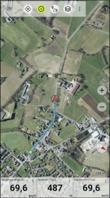
Offroad navigation app with worldwide topographic maps (mainly Russian general staff maps). There are also many other map layers with up-to-date and detailed maps or aerial photos.
Even though most of the Russian maps date back to the 1980s, they are still among the best topo maps available for many regions in Africa and Asia, especially if you are looking for remote tracks or old infrastructure. All maps are also labelled in English.
Map data can be downloaded so that the application can also be used without internet reception. No user data is collected by the app!
Selectable map layers (worldwide):
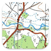
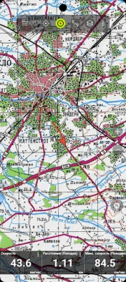
• Topo maps (worldwide coverage 1:100,000 - 1:200,000) Russian General Staff maps - Genshtab
• GGC Gosgiscentr Topo maps Russia 1:25,000 - 1:200,000
• ROSREESTR The Federal Service for State Registration, Cadastre and Cartography (only Russia. Up-to-date and very detailed)
• Yandex Maps: Satellite images, road map. (Online use only!)
• Openstreetmap: excellent maps with different styles as well as shading & contour lines): OSM Topo, OSM Cycle Map (especially for cyclists), OSM Outdoors (for hikers), OSM Landscape
• Google Maps: Satellite images, road and terrain maps. (Online use only!)
• Bing Maps: Satellite images and street map. (Online use only !)
• ESRI Maps: Satellite images, street and terrain map.
All maps can be created as overlays and compared with each other using a transparency slider.
Switchable overlays (worldwide):
• Hillshading
• 20m contour lines
- OpenSeaMap
This app offers all functions for comprehensive outdoor navigation:
• Download of maps for OFFLINE operation (except Google, Bing & Yandex Maps)
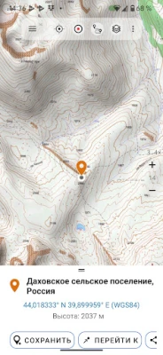
• Create waypoints
• GoTo waypoint navigation
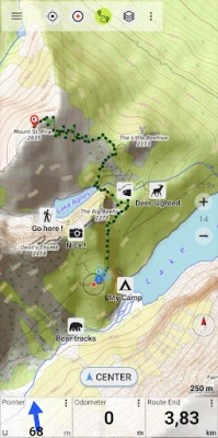
• Create and navigate routes (with automatic route calculation based on OpenStreetMaps)
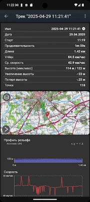
• Track recording (evaluation with speed and altitude profile)
• Freely configurable data fields in the map view (e.g. speed, altitude)
• Tripmaster with fields for daily kilometres, average, distance, compass, etc.
• GPX/KML/KMZ import export
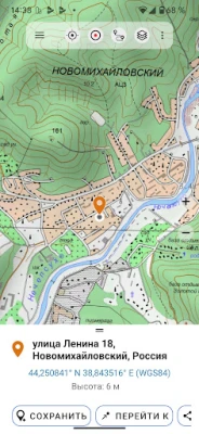
• Search function (locations, POIs, street names)
• Waypoint/track sharing (via e-mail, WhatsApp, ...)
• Measurement of paths and areas
• UMTS/MGRS GRID
Other maps can be imported in common formats:
• GeoPDF
• GeoTiff
• MBTiles
• Ozi (Oziexplorer OZF2 & OZF3)
• Online map services can be integrated as WMS servers or XYZ tile servers.
• OpenStreetMap maps can also be downloaded country by country in space-saving vector format!
LIMITATIONS OF THIS FREE VERSION:
• Ads
• Max. 10 Waypoints
• Max. 5 Tracks
• No import/export of waypoints/tracks/routes
• No import of maps (WMS, GeoTiff, GeoPDF, MBTiles)
• No Cache download for offline use
• No Local City DB (Offline Search)
• No Route navigation
For questions please contact [email protected]
Map data can be downloaded so that the application can also be used without internet reception. No user data is collected by the app!
Selectable map layers (worldwide):
• Topo maps (worldwide coverage 1:100,000 - 1:200,000) Russian General Staff maps - Genshtab
• GGC Gosgiscentr Topo maps Russia 1:25,000 - 1:200,000
• ROSREESTR The Federal Service for State Registration, Cadastre and Cartography (only Russia. Up-to-date and very detailed)
• Yandex Maps: Satellite images, road map. (Online use only!)
• Openstreetmap: excellent maps with different styles as well as shading & contour lines): OSM Topo, OSM Cycle Map (especially for cyclists), OSM Outdoors (for hikers), OSM Landscape
• Google Maps: Satellite images, road and terrain maps. (Online use only!)
• Bing Maps: Satellite images and street map. (Online use only !)
• ESRI Maps: Satellite images, street and terrain map.
All maps can be created as overlays and compared with each other using a transparency slider.
Switchable overlays (worldwide):
• Hillshading
• 20m contour lines
- OpenSeaMap
This app offers all functions for comprehensive outdoor navigation:
• Download of maps for OFFLINE operation (except Google, Bing & Yandex Maps)
• Create waypoints
• GoTo waypoint navigation
• Create and navigate routes (with automatic route calculation based on OpenStreetMaps)
• Track recording (evaluation with speed and altitude profile)
• Freely configurable data fields in the map view (e.g. speed, altitude)
• Tripmaster with fields for daily kilometres, average, distance, compass, etc.
• GPX/KML/KMZ import export
• Search function (locations, POIs, street names)
• Waypoint/track sharing (via e-mail, WhatsApp, ...)
• Measurement of paths and areas
• UMTS/MGRS GRID
Other maps can be imported in common formats:
• GeoPDF
• GeoTiff
• MBTiles
• Ozi (Oziexplorer OZF2 & OZF3)
• Online map services can be integrated as WMS servers or XYZ tile servers.
• OpenStreetMap maps can also be downloaded country by country in space-saving vector format!
LIMITATIONS OF THIS FREE VERSION:
• Ads
• Max. 10 Waypoints
• Max. 5 Tracks
• No import/export of waypoints/tracks/routes
• No import of maps (WMS, GeoTiff, GeoPDF, MBTiles)
• No Cache download for offline use
• No Local City DB (Offline Search)
• No Route navigation
For questions please contact [email protected]
Rate the App
Add Comment & Review
User Reviews
Based on 0 reviews
No reviews added yet.
Comments will not be approved to be posted if they are SPAM, abusive, off-topic, use profanity, contain a personal attack, or promote hate of any kind.


More »

Popular Apps

phpFoxPHPFOX LLC

Moon Chai StoryOlha Dobel

World War Heroes — WW2 PvP FPSAzur Interactive Games Limited

Govee LiteGovee

Build World AdventureExplore city in cube world
Viking Clan: RagnarokKano Games

Vikings: War of ClansPlarium LLC

Submarine Car Diving SimulatorSwim with dolphins & penguins

Asphalt 9: LegendsGameloft SE
Dawn of Zombies: Survival GameRoyal Ark
More »
Editor's Choice

Grim Soul: Dark Survival RPGBrickworks Games Ltd

Craft of Survival - Gladiators101XP LIMITED

Last Shelter: SurvivalLong Tech Network Limited
Dawn of Zombies: Survival GameRoyal Ark

Merge Survival : WastelandStickyHands Inc.

AoD Vikings: Valhalla GameRoboBot Studio
Viking Clan: RagnarokKano Games
Vikings: War of ClansPlarium LLC
Asphalt 9: LegendsGameloft SE

Modern Tanks: War Tank GamesXDEVS LTD