
Latest Version
Update
October 29, 2026
October 29, 2026
Developer
Cognition Origin
Cognition Origin
Categories
Maps & Navigation
Maps & Navigation
Platforms
Android
Android
Downloads
0
0
License
$5.99
$5.99
Package Name
com.cognitionorigin.militarygps
com.cognitionorigin.militarygps
Report
Report a Problem
Report a Problem
More About Military GPS Pro: MGRS UTM Map
Military GPS Pro (MilGPS for short) is an offline tactical map and GPS navigation app. With its GPS tools you navigate, explore, hike and rescue: live MGRS and UTM GPS coordinates, a GPS coordinates converter, a mils compass, a GPS tracker, a GPS map camera with timestamp and photo tag, a GPS field measure and 3D terrain. An army land navigation and hiking GPS with no subscription, no ads and no account.
Purchase one time, get all premium tools
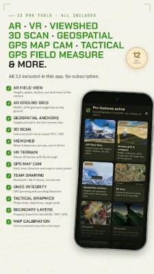
One purchase includes all 12 pro tools, tools often sold separately or by subscription. Nothing more to unlock:
• AR Field View: targets, peaks, skyline, sun and moon over the camera view.
• AR Pro (ARCore phones): MGRS ground grid and compass, Geospatial anchors for targets (internet) and a 3D scanner (point cloud) on phones with depth support.
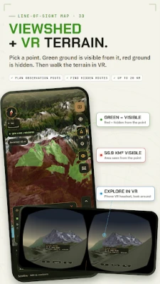
• Viewshed from up to four points; VR terrain in a phone VR viewer with route fly-through.
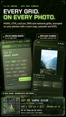
• Camera with MGRS photo stamp.
• Encrypted offline team sharing: Bluetooth / Wi-Fi Direct, LoRa mesh radios, Cursor-on-Target.
• GPS jammer detector: jamming and spoofing detection (GNSS integrity).
• Tactical graphics, boundary layers (GeoJSON, shapefile, KML) and map calibration of scanned paper maps.
MGRS and UTM grid coordinates
• 18 formats: MGRS, UTM, USNG, Lat/Lon, DMS, DMM, WGS84, ED50, QTH locator, BNG (OS grid reference), Irish Grid, EOV, SK-42, VN-2000, ΕΓΣΑ87, Stereo 70, TUREF and ED50 TM3.
• Ten-digit MGRS, live GPS speed, altimeter, Zulu time and DTG.
Offline topo maps with MGRS grid
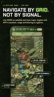
• Satellite, topo, relief and night maps with MGRS / UTM grid, hillshade and contour lines.
• Download offline maps; MBTiles, GeoPackage, GeoTIFF and georeferenced GeoPDF maps; print to PDF at 1:25 000.
Mils compass for army land navigation
• True, magnetic and grid north with automatic declination and G-M angle; NATO mils (6400), 6000 mils, degrees or gon.
• Land nav tools: bearing lock, back azimuth, steering to a target, resection, intersection, pace counter, time-speed-distance, line of sight calculator and dead reckoning.
Waypoints, routes and GPS tracks
• Waypoints with APP-6 / MIL-STD-2525 frames, photos and proximity alerts.
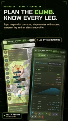
• Routes with elevation profile; travel mode with off-course warning and ETA.
• GPX track recorder (screen off) with 3D replay, splits and backtrack.
• GPX viewer and KML / KMZ file viewer; export GPX, KML and KMZ.
GPS field area measure and land area calculator
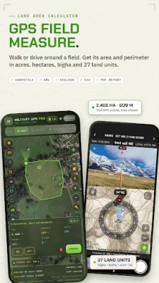
• Land measurement by walking or driving the boundary (screen off too), corner by corner with GPS averaging, on the map or from typed coordinates.
• Area on the WGS 84 ellipsoid, perimeter, side lengths, GPS accuracy and uncertainty.
• 37 area units: acres, half acres, hectares, m², ft², dönüm, sotka, marla, kanal, guntha, cent, mu, rai, feddan, and bigha and katha for Bangladesh and Indian states.
• Acre calculator for farms and plots: save fields with notes and photos.
• Export KML, KMZ, GeoJSON, CSV, shapefile, PDF report or JPG; import KML, KMZ, GeoJSON.
GPS map camera with MGRS photo stamp
• Geotag photos with a location stamp: mini map with MGRS grid and view direction, MGRS plus latitude/longitude, UTM or a national grid, altitude, azimuth, accuracy, date and timestamp with DTG.
• Optional address, weather and note.
• Position, time and direction in the EXIF, a gallery copy; works offline.
Field tools
• Night-vision red mode, sun and moon almanac, 9-line MEDEVAC and SALUTE reports, SMEAC / WARNO briefings.
• Distance meter, range circles and geofence alarms.
• Search and rescue: POA / POD / POS from tracks, clue log, SAR report.
• Wear OS: MGRS and steering arrow on your watch.
Offline and private
• Waypoints, tracks, fields and photos stay on your phone; no account.
• Online maps, weather, addresses and first map downloads need internet.
• Interface in 35 languages.
For soldiers, SAR teams, hunters and hikers, orienteering, radio amateurs, farmers, real estate agents and inspectors.
Rate the App
Add Comment & Review
User Reviews
Based on 0 reviews
No reviews added yet.
Comments will not be approved to be posted if they are SPAM, abusive, off-topic, use profanity, contain a personal attack, or promote hate of any kind.













More »

Popular Apps

phpFoxPHPFOX LLC

Moon Chai StoryOlha Dobel

World War Heroes — WW2 PvP FPSAzur Interactive Games Limited

Govee LiteGovee

AvSeaAvionics Electronics Geeks!

Viking Clan: RagnarokKano Games

Vikings: War of ClansPlarium LLC

Build World AdventureExplore city in cube world

Asphalt 9: LegendsGameloft SE
Dawn of Zombies: Survival GameRoyal Ark
More »
Editor's Choice

Grim Soul: Dark Survival RPGBrickworks Games Ltd

Craft of Survival - Gladiators101XP LIMITED

Last Shelter: SurvivalLong Tech Network Limited
Dawn of Zombies: Survival GameRoyal Ark

Merge Survival : WastelandStickyHands Inc.

AoD Vikings: Valhalla GameRoboBot Studio
Viking Clan: RagnarokKano Games
Vikings: War of ClansPlarium LLC
Asphalt 9: LegendsGameloft SE
Modern Tanks: War Tank GamesXDEVS LTD