Latest Version
Update
February 19, 2026
February 19, 2026
Developer
NotSized
NotSized
Categories
Maps & Navigation
Maps & Navigation
Platforms
Android
Android
Downloads
1
1
License
$14.99
$14.99
Package Name
com.notsized.kartal
com.notsized.kartal
Report
Report a Problem
Report a Problem
More About KARTAL MGRS - UTM MAP
The comprehensive navigation suite for the field, missions, and professional outdoor use. Kartal MGRS is a high-precision GPS and mapping application designed specifically for military personnel, search and rescue teams, and outdoor professionals who require absolute accuracy.
Master the terrain with a modern interface, robust offline support, and advanced tactical features designed for reliability in the most demanding environments.
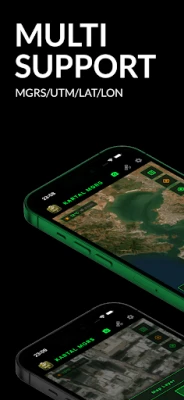
Precision Coordinate Systems
-Real-Time Tracking: Instant support for MGRS, UTM, Latitude/Longitude, and Military Grid systems.
-Go-To-Coord: Navigate directly to specific coordinate inputs with high-precision guidance.
-Precise Sharing: Share your location in professional MGRS and UTM formats for seamless team coordination.
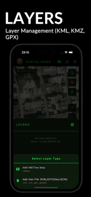
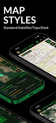
Professional Map Management and Offline Access
-Map Variety: Access Standard, Satellite, Topographical, and Dark Mode map layers.
-Offline Maps: Download specific map regions to ensure functionality in areas without cellular or data coverage.
-Custom Layers: Full support for importing your own MBTiles, KML, KMZ, GPX, and GeoJSON files.
Tactical Camera and Metadata
-Data Overlay: Automatically stamp coordinates, direction (Azimuth), and timestamps directly onto your photos.
-Professional Documentation: Use tactical overlays for mission reporting and terrain analysis.
Advanced Compass and Angular Units
-Universal Standards: Comprehensive support for 360 Degrees, NATO Mils (6400), and Grad units.
-Directional Accuracy: Switch between Magnetic and True North for pinpoint navigation.
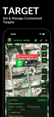
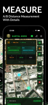
Measurement and Target Management
-Terrain Analysis: Measure distance, elevation difference, and slope between any two points or from your current position.
-Target List: Save critical waypoints, customize icons, and organize your operational routes.
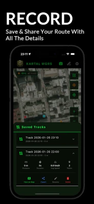
Track Recording and Data Export
-Mission Logging: Record your movement, tracking average speed, duration, and distance.
-Universal Compatibility: Export your recorded tracks in GPX, KML, or KMZ formats for use in other GIS platforms.
Night Mode HUD
-Tactical Visibility: Low-light red filter support to preserve night vision and maintain operational stealth.
WHY KARTAL MGRS?
-Simple and Powerful: A streamlined interface that prioritizes fast access to critical tools over complex menus.
-Battery Efficiency: Optimized GPS algorithms to extend device battery life during prolonged field use.
-Secure and Independent: Your data remains on your device. No cloud dependency or external data tracking.
Precision Coordinate Systems
-Real-Time Tracking: Instant support for MGRS, UTM, Latitude/Longitude, and Military Grid systems.
-Go-To-Coord: Navigate directly to specific coordinate inputs with high-precision guidance.
-Precise Sharing: Share your location in professional MGRS and UTM formats for seamless team coordination.
Professional Map Management and Offline Access
-Map Variety: Access Standard, Satellite, Topographical, and Dark Mode map layers.
-Offline Maps: Download specific map regions to ensure functionality in areas without cellular or data coverage.
-Custom Layers: Full support for importing your own MBTiles, KML, KMZ, GPX, and GeoJSON files.
Tactical Camera and Metadata
-Data Overlay: Automatically stamp coordinates, direction (Azimuth), and timestamps directly onto your photos.
-Professional Documentation: Use tactical overlays for mission reporting and terrain analysis.
Advanced Compass and Angular Units
-Universal Standards: Comprehensive support for 360 Degrees, NATO Mils (6400), and Grad units.
-Directional Accuracy: Switch between Magnetic and True North for pinpoint navigation.
Measurement and Target Management
-Terrain Analysis: Measure distance, elevation difference, and slope between any two points or from your current position.
-Target List: Save critical waypoints, customize icons, and organize your operational routes.
Track Recording and Data Export
-Mission Logging: Record your movement, tracking average speed, duration, and distance.
-Universal Compatibility: Export your recorded tracks in GPX, KML, or KMZ formats for use in other GIS platforms.
Night Mode HUD
-Tactical Visibility: Low-light red filter support to preserve night vision and maintain operational stealth.
WHY KARTAL MGRS?
-Simple and Powerful: A streamlined interface that prioritizes fast access to critical tools over complex menus.
-Battery Efficiency: Optimized GPS algorithms to extend device battery life during prolonged field use.
-Secure and Independent: Your data remains on your device. No cloud dependency or external data tracking.
Rate the App
Add Comment & Review
User Reviews
Based on 0 reviews
No reviews added yet.
Comments will not be approved to be posted if they are SPAM, abusive, off-topic, use profanity, contain a personal attack, or promote hate of any kind.


More »

Popular Apps

phpFoxPHPFOX LLC

Moon Chai StoryOlha Dobel

World War Heroes — WW2 PvP FPSAzur Interactive Games Limited

Govee LiteGovee

Build World AdventureExplore city in cube world
Viking Clan: RagnarokKano Games
Vikings: War of ClansPlarium LLC

Asphalt 9: LegendsGameloft SE

Submarine Car Diving SimulatorSwim with dolphins & penguins
Dawn of Zombies: Survival GameRoyal Ark
More »
Editor's Choice

Grim Soul: Dark Survival RPGBrickworks Games Ltd

Craft of Survival - Gladiators101XP LIMITED

Last Shelter: SurvivalLong Tech Network Limited
Dawn of Zombies: Survival GameRoyal Ark

Merge Survival : WastelandStickyHands Inc.

AoD Vikings: Valhalla GameRoboBot Studio
Viking Clan: RagnarokKano Games
Vikings: War of ClansPlarium LLC
Asphalt 9: LegendsGameloft SE

Modern Tanks: War Tank GamesXDEVS LTD