
Latest Version
Update
June 12, 2026
June 12, 2026
Developer
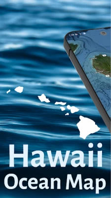
Hawaii Ocean Map
Hawaii Ocean Map
Categories
Maps & Navigation
Maps & Navigation
Platforms
Android
Android
Downloads
0
0
License
$9.99
$9.99
Package Name
com.hawaiioceanmap
com.hawaiioceanmap
Report
Report a Problem
Report a Problem
More About Hawaii Ocean Map
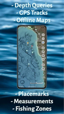
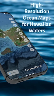
Hawaii Ocean Map brings professional-grade seafloor mapping to your Android device. Explore the depths around the Hawaiian Islands with NOAA's high-resolution bathymetry data—all available offline, with no subscription required.
PROFESSIONAL DEPTH DATA
Access detailed ocean floor topography derived from NOAA's Continuously Updated Digital Elevation Model (CUDEM) at approximately 3-meter resolution. Find underwater features including reefs, ledges, channels, and drop-offs with precision.
WORKS OFFLINE
Download maps before you head out. Whether you're miles offshore or in areas with no cell coverage, your depth data is always available. Perfect for ocean adventures beyond the reach of cellular networks.
INSTANT DEPTH QUERIES
Tap anywhere on the map to instantly see the water depth at that location. Plan routes, identify fishing spots, or explore underwater terrain with a simple touch.
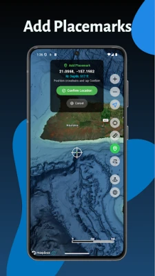
SAVE LOCATIONS
Mark and save your favorite spots with custom placemarks. Add names, notes, and organize your locations for quick reference on future trips.
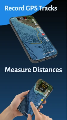
RECORD GPS TRACKS
Capture your routes as you explore Hawaii's waters. Start, pause, and resume recording, then export your tracks as standard GPX files to share or analyze. Your tracks sync automatically across all your devices.
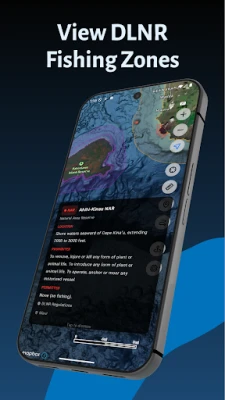
FISHING RESTRICTION ZONES
View DLNR marine managed areas including Marine Life Conservation Districts, Fisheries Management Areas, and more. Tap any zone to see official regulations—what's permitted, what's prohibited, and links to full DLNR rules. Toggle zones by region in settings.
MEASURE DISTANCES
Use the built-in measurement tool to calculate distances between any two points on the map.
FULL ISLAND COVERAGE
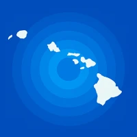
Complete bathymetry coverage for all major Hawaiian Islands—Oahu, Maui, Big Island, Kauai, Molokai, Lanai, and surrounding waters.
NO SUBSCRIPTIONS
One purchase, lifetime access. No recurring fees, no in-app purchases, no ads.
Ideal for boaters, fishermen, divers, snorkelers, kayakers, and anyone who wants to understand what lies beneath Hawaii's beautiful waters.
Access detailed ocean floor topography derived from NOAA's Continuously Updated Digital Elevation Model (CUDEM) at approximately 3-meter resolution. Find underwater features including reefs, ledges, channels, and drop-offs with precision.
WORKS OFFLINE
Download maps before you head out. Whether you're miles offshore or in areas with no cell coverage, your depth data is always available. Perfect for ocean adventures beyond the reach of cellular networks.
INSTANT DEPTH QUERIES
Tap anywhere on the map to instantly see the water depth at that location. Plan routes, identify fishing spots, or explore underwater terrain with a simple touch.
SAVE LOCATIONS
Mark and save your favorite spots with custom placemarks. Add names, notes, and organize your locations for quick reference on future trips.
RECORD GPS TRACKS
Capture your routes as you explore Hawaii's waters. Start, pause, and resume recording, then export your tracks as standard GPX files to share or analyze. Your tracks sync automatically across all your devices.
FISHING RESTRICTION ZONES
View DLNR marine managed areas including Marine Life Conservation Districts, Fisheries Management Areas, and more. Tap any zone to see official regulations—what's permitted, what's prohibited, and links to full DLNR rules. Toggle zones by region in settings.
MEASURE DISTANCES
Use the built-in measurement tool to calculate distances between any two points on the map.
FULL ISLAND COVERAGE
Complete bathymetry coverage for all major Hawaiian Islands—Oahu, Maui, Big Island, Kauai, Molokai, Lanai, and surrounding waters.
NO SUBSCRIPTIONS
One purchase, lifetime access. No recurring fees, no in-app purchases, no ads.
Ideal for boaters, fishermen, divers, snorkelers, kayakers, and anyone who wants to understand what lies beneath Hawaii's beautiful waters.
Rate the App
Add Comment & Review
User Reviews
Based on 0 reviews
No reviews added yet.
Comments will not be approved to be posted if they are SPAM, abusive, off-topic, use profanity, contain a personal attack, or promote hate of any kind.


More »

Popular Apps

phpFoxPHPFOX LLC

Moon Chai StoryOlha Dobel

World War Heroes — WW2 PvP FPSAzur Interactive Games Limited

Govee LiteGovee

Build World AdventureExplore city in cube world

Viking Clan: RagnarokKano Games

Vikings: War of ClansPlarium LLC

Asphalt 9: LegendsGameloft SE

Submarine Car Diving SimulatorSwim with dolphins & penguins

Dawn of Zombies: Survival GameRoyal Ark
More »
Editor's Choice

Grim Soul: Dark Survival RPGBrickworks Games Ltd

Craft of Survival - Gladiators101XP LIMITED

Last Shelter: SurvivalLong Tech Network Limited
Dawn of Zombies: Survival GameRoyal Ark

Merge Survival : WastelandStickyHands Inc.

AoD Vikings: Valhalla GameRoboBot Studio
Viking Clan: RagnarokKano Games
Vikings: War of ClansPlarium LLC
Asphalt 9: LegendsGameloft SE

Modern Tanks: War Tank GamesXDEVS LTD