
Latest Version
Version
1.5.3
1.5.3
Update
November 04, 2025
November 04, 2025
Developer
4Digsoft
4Digsoft
Categories
Tools
Tools
Platforms
Android
Android
Downloads
0
0
License
Free
Free
Package Name
glandgo.gpsarea.fieldareameasure
glandgo.gpsarea.fieldareameasure
Report
Report a Problem
Report a Problem
More About GPS Field Measure - GLandGo
Measure land area, distance, and perimeter with precision using your device's GPS.
GLandGo is the smart, reliable, and professional GPS Area Measurement app designed for accurate land surveying. Whether you’re measuring fields, tracking distances, or managing land data, GLandGo gives you full control — right from your mobile device.
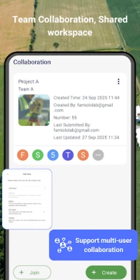
✅Major Update: Collaboration Mode Now you can create projects, add multiple accounts, and work together with your team. All members’ measurement records are synced in real time, and different project roles come with different permissions – making teamwork smooth and efficient.
🌍 Key Features:
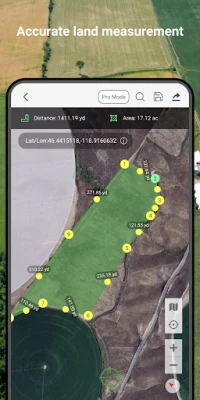
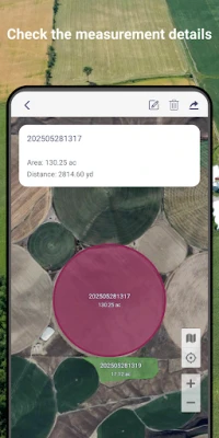
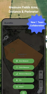
1. GPS Area Measurement
Measure land by walking the perimeter or placing points manually on the map.
Save results with names, notes, photos, and categories.
Multiple units supported: hectares, acres, square meters, etc.
2. Distance Measurement
Track path lengths and calculate straight-line or multi-point distances.
Supports GPS tracking and manual distance input.
3. Manual Coordinate Input
NEW: Precisely add points by entering latitude and longitude.
Useful for remote mapping and GPS data referencing.
4. Location Marking & Organization
Save and categorize important locations for future reference.
5. GPS Tools & Navigation
Built-in compass for field alignment.
Real-time GPS tracking, direction, and satellite positioning.
6. Import & Export Support
Import: SHP, GeoJSON, KML, KMZ
Export: SHP, KML, JPG, PDF, GeoJSON
Share measurement results via custom web links.
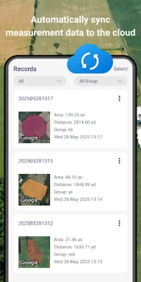
7. GLandGo Cloud
Protect your data with built-in cloud/local backup options.
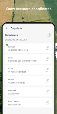
8. Professional Mapping Support:
Coordinate formats: DMS, UTM, MGRS, Plus Code, Geohash
Map history tracking
Customizable map types and themes
9. Collaboration – add multiple users to projects, assign roles, and collaborate with real-time data sync
10. Cross-Platform Sync - Log in with your account and seamlessly access your data across both Android and iOS devices. Whether you switch phones or use multiple platforms, your data stays synchronized in the cloud.
11. Circle Area Measurement – Quickly measure circular plots of land by setting the center and radius.
12. Manual Coordinate Entry – Add precise location points by entering coordinates manually.
New ! Add Image Layers for Smarter Field Mapping
Enhance your GPS Area Measure and Field Area Measure experience with the new Image Layer feature. Now you can import and overlay images directly on the map — perfect for comparing drone photos, survey maps, or satellite shots.
This update makes area measurement and distance measure more visual and accurate, helping you manage land, farms, or projects with ease.
Whether you use it for Measure Map Pro, land planning, or professional area app tasks, you’ll enjoy a smarter, clearer gps measure and area measure workflow.
👥 Perfect For:
Farmers & Agronomists
Land Surveyors
Real Estate Professionals
Engineers & Architects
Environmental Planners
Outdoor Enthusiasts & Hikers
GIS Survery
GLandGo is your GPS Fields Area Measure Map, Map Area Calculator, Field Area Measure, and GPS Land Measurement & Survey solution – smart, simple, and accurate.
Download GLandGo – GPS Area Measurement today and experience the easiest and most powerful way to measure land and distances anywhere.
✅Major Update: Collaboration Mode Now you can create projects, add multiple accounts, and work together with your team. All members’ measurement records are synced in real time, and different project roles come with different permissions – making teamwork smooth and efficient.
🌍 Key Features:
1. GPS Area Measurement
Measure land by walking the perimeter or placing points manually on the map.
Save results with names, notes, photos, and categories.
Multiple units supported: hectares, acres, square meters, etc.
2. Distance Measurement
Track path lengths and calculate straight-line or multi-point distances.
Supports GPS tracking and manual distance input.
3. Manual Coordinate Input
NEW: Precisely add points by entering latitude and longitude.
Useful for remote mapping and GPS data referencing.
4. Location Marking & Organization
Save and categorize important locations for future reference.
5. GPS Tools & Navigation
Built-in compass for field alignment.
Real-time GPS tracking, direction, and satellite positioning.
6. Import & Export Support
Import: SHP, GeoJSON, KML, KMZ
Export: SHP, KML, JPG, PDF, GeoJSON
Share measurement results via custom web links.
7. GLandGo Cloud
Protect your data with built-in cloud/local backup options.
8. Professional Mapping Support:
Coordinate formats: DMS, UTM, MGRS, Plus Code, Geohash
Map history tracking
Customizable map types and themes
9. Collaboration – add multiple users to projects, assign roles, and collaborate with real-time data sync
10. Cross-Platform Sync - Log in with your account and seamlessly access your data across both Android and iOS devices. Whether you switch phones or use multiple platforms, your data stays synchronized in the cloud.
11. Circle Area Measurement – Quickly measure circular plots of land by setting the center and radius.
12. Manual Coordinate Entry – Add precise location points by entering coordinates manually.
New ! Add Image Layers for Smarter Field Mapping
Enhance your GPS Area Measure and Field Area Measure experience with the new Image Layer feature. Now you can import and overlay images directly on the map — perfect for comparing drone photos, survey maps, or satellite shots.
This update makes area measurement and distance measure more visual and accurate, helping you manage land, farms, or projects with ease.
Whether you use it for Measure Map Pro, land planning, or professional area app tasks, you’ll enjoy a smarter, clearer gps measure and area measure workflow.
👥 Perfect For:
Farmers & Agronomists
Land Surveyors
Real Estate Professionals
Engineers & Architects
Environmental Planners
Outdoor Enthusiasts & Hikers
GIS Survery
GLandGo is your GPS Fields Area Measure Map, Map Area Calculator, Field Area Measure, and GPS Land Measurement & Survey solution – smart, simple, and accurate.
Download GLandGo – GPS Area Measurement today and experience the easiest and most powerful way to measure land and distances anywhere.
Rate the App
Add Comment & Review
User Reviews
Based on 0 reviews
No reviews added yet.
Comments will not be approved to be posted if they are SPAM, abusive, off-topic, use profanity, contain a personal attack, or promote hate of any kind.


More »

Popular Apps

Moon Chai StoryOlha Dobel

phpFoxPHPFOX LLC

Govee LiteGovee

World War Heroes — WW2 PvP FPSAzur Interactive Games Limited

Build World AdventureExplore city in cube world

Viking Clan: RagnarokKano Games

Vikings: War of ClansPlarium LLC

Asphalt 9: LegendsGameloft SE

Submarine Car Diving SimulatorSwim with dolphins & penguins

Union VPN - Secure VPN ProxyPureBrowser
More »
Editor's Choice

Grim Soul: Dark Survival RPGBrickworks Games Ltd

Craft of Survival - Gladiators101XP LIMITED

Last Shelter: SurvivalLong Tech Network Limited

Dawn of Zombies: Survival GameRoyal Ark

Merge Survival : WastelandStickyHands Inc.

AoD Vikings: Valhalla GameRoboBot Studio
Viking Clan: RagnarokKano Games
Vikings: War of ClansPlarium LLC
Asphalt 9: LegendsGameloft SE

Modern Tanks: War Tank GamesXDEVS LTD