

Latest Version
Update
July 01, 2026
July 01, 2026
Developer
APCORE Dev Team
APCORE Dev Team
Categories
Productivity
Productivity
Platforms
Android
Android
Downloads
0
0
License
Free
Free
Package Name
com.faenaoffline.faenaofflinemaps
com.faenaoffline.faenaofflinemaps
Report
Report a Problem
Report a Problem
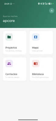
More About FO Maps - FaenaOffline GIS
FO Maps from FaenaOffline is the offline GIS app for professionals working where there's no signal: forest roads, remote field operations, on-site installations.
One tool built for the real field: forget switching between maps, spreadsheets and messages to coordinate your team.
▸ OFFLINE MAPS AND PLANS
• Import GeoPDF, KML and KMZ from QGIS, ArcGIS or AutoCAD
• Pre-loaded OpenStreetMap, no Wi-Fi needed
• Multiple overlapping layers with filters
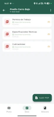
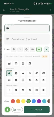
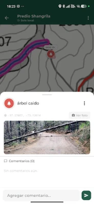
▸ MARKERS AND LOGBOOK
• Drop pins via GPS or manual crosshair
• Attach georeferenced photos
• Custom templates: text, number, dropdown, photo
• Status tracking (Pending / In Progress / Resolved)
▸ CHANNELS FOR YOUR TEAM
• Share projects with a code (no servers to set up)
• Your crew sees plans, markers and logbook — offline
• Auto-sync when signal returns
▸ VECTOR DRAWING
• Lines, polygons and routes directly on the plan
• KML import / export
▸ EXPORT
• KML / KMZ with embedded photos
• CSV with all fields
• PDF report per project
• Auto-sync to Google Sheets
▸ AVAILABLE IN 11 LANGUAGES
ES · EN · PT · FR · DE · ID · ZH · JA · KO · AR · HI
USED BY PROFESSIONALS IN
Chile · Canada · Brazil · Germany · Australia · Colombia
Ideal for surveying, forestry engineering, electrical installation, precision agriculture, environmental monitoring, infrastructure.
Support: [email protected]
Web: https://faenaoffline.com/maps/
▸ OFFLINE MAPS AND PLANS
• Import GeoPDF, KML and KMZ from QGIS, ArcGIS or AutoCAD
• Pre-loaded OpenStreetMap, no Wi-Fi needed
• Multiple overlapping layers with filters
▸ MARKERS AND LOGBOOK
• Drop pins via GPS or manual crosshair
• Attach georeferenced photos
• Custom templates: text, number, dropdown, photo
• Status tracking (Pending / In Progress / Resolved)
▸ CHANNELS FOR YOUR TEAM
• Share projects with a code (no servers to set up)
• Your crew sees plans, markers and logbook — offline
• Auto-sync when signal returns
▸ VECTOR DRAWING
• Lines, polygons and routes directly on the plan
• KML import / export
▸ EXPORT
• KML / KMZ with embedded photos
• CSV with all fields
• PDF report per project
• Auto-sync to Google Sheets
▸ AVAILABLE IN 11 LANGUAGES
ES · EN · PT · FR · DE · ID · ZH · JA · KO · AR · HI
USED BY PROFESSIONALS IN
Chile · Canada · Brazil · Germany · Australia · Colombia
Ideal for surveying, forestry engineering, electrical installation, precision agriculture, environmental monitoring, infrastructure.
Support: [email protected]
Web: https://faenaoffline.com/maps/
Rate the App
Add Comment & Review
User Reviews
Based on 0 reviews
No reviews added yet.
Comments will not be approved to be posted if they are SPAM, abusive, off-topic, use profanity, contain a personal attack, or promote hate of any kind.


More »

Popular Apps

phpFoxPHPFOX LLC

Moon Chai StoryOlha Dobel

World War Heroes — WW2 PvP FPSAzur Interactive Games Limited

Govee LiteGovee

Build World AdventureExplore city in cube world

Viking Clan: RagnarokKano Games

Vikings: War of ClansPlarium LLC

Asphalt 9: LegendsGameloft SE

Submarine Car Diving SimulatorSwim with dolphins & penguins

Dawn of Zombies: Survival GameRoyal Ark
More »
Editor's Choice

Grim Soul: Dark Survival RPGBrickworks Games Ltd

Craft of Survival - Gladiators101XP LIMITED

Last Shelter: SurvivalLong Tech Network Limited
Dawn of Zombies: Survival GameRoyal Ark

Merge Survival : WastelandStickyHands Inc.

AoD Vikings: Valhalla GameRoboBot Studio
Viking Clan: RagnarokKano Games
Vikings: War of ClansPlarium LLC
Asphalt 9: LegendsGameloft SE

Modern Tanks: War Tank GamesXDEVS LTD