

Latest Version
Update
April 27, 2026
April 27, 2026
Developer
Diamondback
Diamondback
Categories
Maps & Navigation
Maps & Navigation
Platforms
Android
Android
Downloads
0
0
License
Free
Free
Package Name
app.cohunt
app.cohunt
Report
Report a Problem
Report a Problem
More About CoHunt: Hunting Maps & GPS
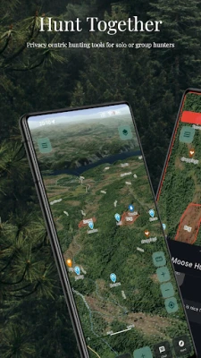
Hunt together or solo, even when cell towers are miles away. CoHunt is a hunting app with p2p mesh messaging, keeping your group connected deep in the backcountry. Property lines, offline maps, GPS tracking, and ballistics built by hunters for real field conditions.
Why Hunters Switch to CoHunt
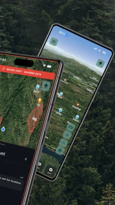
Your hunting party needs to know where everyone is. During a drive hunt, one wrong position can ruin the setup. CoHunt shows every member's location in real-time on hunting maps with property lines marked. When someone spots game or needs help, the group knows instantly.
Offline maps that actually work. Download topo maps, satellite imagery, and land ownership data before heading out. Your GPS hunting tracker works in canyons, timber, and mountains with zero bars. No cell service required.
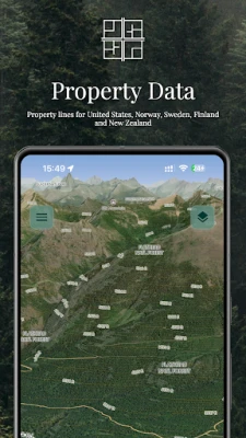
Property Lines That Actually Help
See where public land ends and private property begins. Hunting property line maps show parcel boundaries and landowner info across the United States, Norway, Sweden, Finland, and New Zealand. The land ownership map works offline so you can check boundaries mid-hunt.
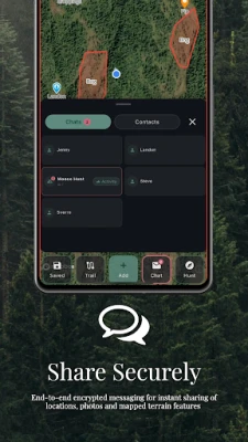
P2P Encrypted Mesh Messaging
Encrypted group messages route automatically over cellular, Wi-Fi, or phone-to-phone bluetooth mesh, whichever reaches your hunting party. End-to-end encrypted with no central servers storing your plans.
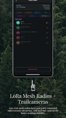
Meshtastic LoRa Radio Support
Pair an inexpensive Meshtastic LoRa radio over bluetooth to extend your group across miles of backcountry. The LoRa mesh relays messages and positions between radios automatically, reaching hunters well beyond limits. Encrypted by default, days of radio battery, no subscription, no cell towers.
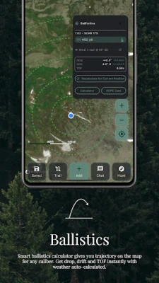
Built-In Ballistics Calculator
Ballistics calculator with G1, G7, and six other drag models. Enter bullet weight, ballistic coefficient, muzzle velocity, sight height, and zero range to calculate bullet drop, windage, velocity, energy, and time of flight at any distance. Supports MOA and MIL with spin drift and Coriolis corrections. Save profiles for multiple rifles and loads. Export DOPE cards as printable PDFs with full trajectory tables. Real-time weather auto-populates temperature, pressure, humidity, and wind for atmospheric corrections. Stability calculator confirms your barrel twist rate stabilizes your projectile.
Plan Smarter with Weather and Wind
Scent analysis models how your scent disperses with wind direction and thermals. Position your tree stand or plan your stalk to stay downwind. Essential for whitetail deer, elk, and any game with a nose.
Track Your Dogs
Integrate with Tractive GPS to monitor bird dogs, hounds, and beagles in real-time. Share dog tracker locations with your hunting party. Beagles on rabbits, pointers on pheasant, or hounds on bear, everyone sees where the dogs are working.
SpyPoint Trail Camera Integration
Connect your SpyPoint cellular trail cameras and see every camera pinned on your hunting map by GPS. Browse photos and videos, monitor battery and signal, and filter by SpyPoint's AI species detection. Know which stand is hot before you climb in.
Mark What Matters
Drop waypoints on rubs, scrapes, bedding areas, game trails, and feeding locations. Mark tree stands, ground blinds, and trail cameras. Share with hunting partners so the whole group hunts smarter. Record GPS tracks to review after the season.
Works Where You Hunt
Multiple map layers including 3D terrain, topographic maps with contour lines, and satellite imagery. Identify funnels, saddles, water sources, and travel corridors. Import and export GPX files for any GPS device.
Your Data Stays Yours
No ads. No analytics tracking. No selling your hunting spots to data brokers. CoHunt collects nothing. Your scouting data and honey holes remain private.
For whitetail deer, mule deer, elk, moose, duck, goose, turkey, pheasant, quail, and predator hunting on public lands or private property. Free hunting maps with property lines and offline GPS. The group hunting app built for real conditions.
Your hunting party needs to know where everyone is. During a drive hunt, one wrong position can ruin the setup. CoHunt shows every member's location in real-time on hunting maps with property lines marked. When someone spots game or needs help, the group knows instantly.
Offline maps that actually work. Download topo maps, satellite imagery, and land ownership data before heading out. Your GPS hunting tracker works in canyons, timber, and mountains with zero bars. No cell service required.
Property Lines That Actually Help
See where public land ends and private property begins. Hunting property line maps show parcel boundaries and landowner info across the United States, Norway, Sweden, Finland, and New Zealand. The land ownership map works offline so you can check boundaries mid-hunt.
P2P Encrypted Mesh Messaging
Encrypted group messages route automatically over cellular, Wi-Fi, or phone-to-phone bluetooth mesh, whichever reaches your hunting party. End-to-end encrypted with no central servers storing your plans.
Meshtastic LoRa Radio Support
Pair an inexpensive Meshtastic LoRa radio over bluetooth to extend your group across miles of backcountry. The LoRa mesh relays messages and positions between radios automatically, reaching hunters well beyond limits. Encrypted by default, days of radio battery, no subscription, no cell towers.
Built-In Ballistics Calculator
Ballistics calculator with G1, G7, and six other drag models. Enter bullet weight, ballistic coefficient, muzzle velocity, sight height, and zero range to calculate bullet drop, windage, velocity, energy, and time of flight at any distance. Supports MOA and MIL with spin drift and Coriolis corrections. Save profiles for multiple rifles and loads. Export DOPE cards as printable PDFs with full trajectory tables. Real-time weather auto-populates temperature, pressure, humidity, and wind for atmospheric corrections. Stability calculator confirms your barrel twist rate stabilizes your projectile.
Plan Smarter with Weather and Wind
Scent analysis models how your scent disperses with wind direction and thermals. Position your tree stand or plan your stalk to stay downwind. Essential for whitetail deer, elk, and any game with a nose.
Track Your Dogs
Integrate with Tractive GPS to monitor bird dogs, hounds, and beagles in real-time. Share dog tracker locations with your hunting party. Beagles on rabbits, pointers on pheasant, or hounds on bear, everyone sees where the dogs are working.
SpyPoint Trail Camera Integration
Connect your SpyPoint cellular trail cameras and see every camera pinned on your hunting map by GPS. Browse photos and videos, monitor battery and signal, and filter by SpyPoint's AI species detection. Know which stand is hot before you climb in.
Mark What Matters
Drop waypoints on rubs, scrapes, bedding areas, game trails, and feeding locations. Mark tree stands, ground blinds, and trail cameras. Share with hunting partners so the whole group hunts smarter. Record GPS tracks to review after the season.
Works Where You Hunt
Multiple map layers including 3D terrain, topographic maps with contour lines, and satellite imagery. Identify funnels, saddles, water sources, and travel corridors. Import and export GPX files for any GPS device.
Your Data Stays Yours
No ads. No analytics tracking. No selling your hunting spots to data brokers. CoHunt collects nothing. Your scouting data and honey holes remain private.
For whitetail deer, mule deer, elk, moose, duck, goose, turkey, pheasant, quail, and predator hunting on public lands or private property. Free hunting maps with property lines and offline GPS. The group hunting app built for real conditions.
Rate the App
Add Comment & Review
User Reviews
Based on 0 reviews
No reviews added yet.
Comments will not be approved to be posted if they are SPAM, abusive, off-topic, use profanity, contain a personal attack, or promote hate of any kind.


More »

Popular Apps

phpFoxPHPFOX LLC

Moon Chai StoryOlha Dobel

World War Heroes — WW2 PvP FPSAzur Interactive Games Limited

Govee LiteGovee

Build World AdventureExplore city in cube world
Viking Clan: RagnarokKano Games

Vikings: War of ClansPlarium LLC

Asphalt 9: LegendsGameloft SE

Submarine Car Diving SimulatorSwim with dolphins & penguins
Dawn of Zombies: Survival GameRoyal Ark
More »
Editor's Choice

Grim Soul: Dark Survival RPGBrickworks Games Ltd

Craft of Survival - Gladiators101XP LIMITED

Last Shelter: SurvivalLong Tech Network Limited
Dawn of Zombies: Survival GameRoyal Ark

Merge Survival : WastelandStickyHands Inc.

AoD Vikings: Valhalla GameRoboBot Studio
Viking Clan: RagnarokKano Games
Vikings: War of ClansPlarium LLC
Asphalt 9: LegendsGameloft SE

Modern Tanks: War Tank GamesXDEVS LTD