
Latest Version
Version
3.0.2
3.0.2
Update
May 29, 2025
May 29, 2025
Developer
Your Guide to BLM Public Lands
Your Guide to BLM Public Lands
Categories
Maps & Navigation
Maps & Navigation
Platforms
iOS
iOS
File Size
95 MB
95 MB
Downloads
0
0
License
$2.99
$2.99
Report
Report a Problem
Report a Problem
More About BLM Public Lands Map Guide USA
If you're looking for an app that will help you to explore every corner of BLM Public Lands in the United States, you're in luck! This is the last app you'll need!!
The United States of America is a vast land full of lush forests, stunning deserts, indescribable landscapes, and fascinating history. You may already know some of the iconic landmarks and wildernesses that the US has to offer, but did you know that there are millions of acres of public Bureau of Land Management property in the Western US? This app is your guide to discovering the unspeakable beauty and recreational potential that is contained within these fabled domains!
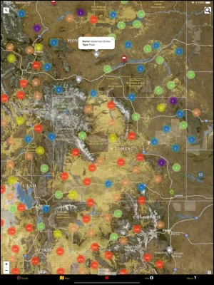
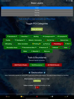
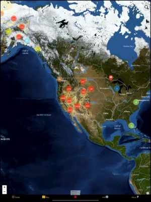
Whether you are a seasoned forest wanderer or are just wanting to learn a little more about the amazing places surrounding your home turf, this app is for you! The data is up to date as of Winter 2025, and contains over 53,000 recreational points and other features on BLM land. These points are symbolized with several color-coded icons that differentiate between the . Categories include Access Points, Boating, Campgrounds, POIs, Vistas, Bathrooms, Parking Lots, Recreational Areas, and much more! The app even distinguishes property boundaries and includes some hiking trails and roads.
New in this release! We listened to your requests and have added several improvements and new features including a custom My Points tool! Now you can save your own points of interest and give them a unique color and icon. Mark where you park the car, where you saw a neat feature, or an epic campsite. You can even export these points for use with other devices!
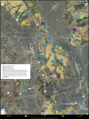
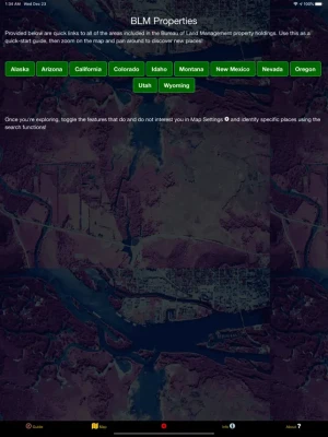
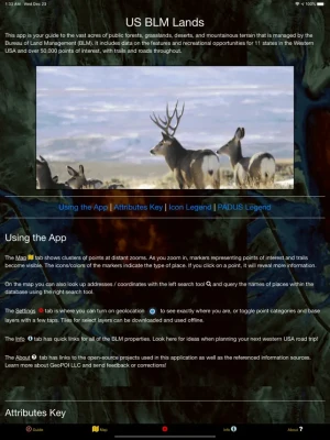
Once using the app, there are five screens. The Guide screen will provide data legends as well as helpful tips for optimizing your navigational experience. On the Info screen, you will find a number of spatial links to the different BLM properties. This is a great way to quickly locate specific places and discover new places to explore! The About screen provides links to all of the open-source resources used in the app and gives a little information about the developer GeoPOI. The Map Settings screen is where you can change between one of four different basemaps, download offline imagery, turn on geolocation, and toggle specific point categories. Finally, the Map screen is where it all comes together!
On the Map screen, there are a series of circle clusters at distant zooms that indicate how many points are within a given cluster. As you tap the clusters to zoom in, individual points and icons become visible, along with trails, roads, and boundaries. These features can be clicked on to reveal the name, location, and other useful information. The map screen also has two search tools - the left one can be used to look up addresses and towns, while the right one will allow you to query the names of the features in the database.
There is such a wealth of beauty out there waiting to be discovered. Never before has it been this easy to navigate our public lands as you travel, no matter where in the United States you are or what kinds of places you are interested in visiting. It's time to experience the rich natural and cultural tapestry of our nation and pay homage to the places that make our country the great land that it is. Come navigate the US BLM lands with GeoPOI today!
Whether you are a seasoned forest wanderer or are just wanting to learn a little more about the amazing places surrounding your home turf, this app is for you! The data is up to date as of Winter 2025, and contains over 53,000 recreational points and other features on BLM land. These points are symbolized with several color-coded icons that differentiate between the . Categories include Access Points, Boating, Campgrounds, POIs, Vistas, Bathrooms, Parking Lots, Recreational Areas, and much more! The app even distinguishes property boundaries and includes some hiking trails and roads.
New in this release! We listened to your requests and have added several improvements and new features including a custom My Points tool! Now you can save your own points of interest and give them a unique color and icon. Mark where you park the car, where you saw a neat feature, or an epic campsite. You can even export these points for use with other devices!
Once using the app, there are five screens. The Guide screen will provide data legends as well as helpful tips for optimizing your navigational experience. On the Info screen, you will find a number of spatial links to the different BLM properties. This is a great way to quickly locate specific places and discover new places to explore! The About screen provides links to all of the open-source resources used in the app and gives a little information about the developer GeoPOI. The Map Settings screen is where you can change between one of four different basemaps, download offline imagery, turn on geolocation, and toggle specific point categories. Finally, the Map screen is where it all comes together!
On the Map screen, there are a series of circle clusters at distant zooms that indicate how many points are within a given cluster. As you tap the clusters to zoom in, individual points and icons become visible, along with trails, roads, and boundaries. These features can be clicked on to reveal the name, location, and other useful information. The map screen also has two search tools - the left one can be used to look up addresses and towns, while the right one will allow you to query the names of the features in the database.
There is such a wealth of beauty out there waiting to be discovered. Never before has it been this easy to navigate our public lands as you travel, no matter where in the United States you are or what kinds of places you are interested in visiting. It's time to experience the rich natural and cultural tapestry of our nation and pay homage to the places that make our country the great land that it is. Come navigate the US BLM lands with GeoPOI today!
Rate the App
Add Comment & Review
User Reviews
Based on 0 reviews
No reviews added yet.
Comments will not be approved to be posted if they are SPAM, abusive, off-topic, use profanity, contain a personal attack, or promote hate of any kind.


More »

Popular Apps

phpFoxPHPFOX LLC

Moon Chai StoryOlha Dobel

World War Heroes — WW2 PvP FPSAzur Interactive Games Limited

Govee LiteGovee

Build World AdventureExplore city in cube world

Viking Clan: RagnarokKano Games

Vikings: War of ClansPlarium LLC

Submarine Car Diving SimulatorSwim with dolphins & penguins

Asphalt 9: LegendsGameloft SE

Dawn of Zombies: Survival GameRoyal Ark
More »
Editor's Choice

Grim Soul: Dark Survival RPGBrickworks Games Ltd

Craft of Survival - Gladiators101XP LIMITED

Last Shelter: SurvivalLong Tech Network Limited
Dawn of Zombies: Survival GameRoyal Ark

Merge Survival : WastelandStickyHands Inc.

AoD Vikings: Valhalla GameRoboBot Studio
Viking Clan: RagnarokKano Games
Vikings: War of ClansPlarium LLC
Asphalt 9: LegendsGameloft SE

Modern Tanks: War Tank GamesXDEVS LTD