
Latest Version
Update
June 21, 2026
June 21, 2026
Developer
WSU Precision Agriculture Lab
WSU Precision Agriculture Lab
Categories
Weather
Weather
Platforms
Android
Android
Downloads
0
0
License
Free
Free
Package Name
com.awn.wsuAgweathernet
com.awn.wsuAgweathernet
Report
Report a Problem
Report a Problem
More About AgWeatherNet
WSU AgWeatherNet puts the power of Washington State University's agricultural weather network right in your pocket.
Access near real-time and forecast weather data from hundreds of stations across Washington State, specifically designed to support farming and agricultural decision-making.
Weather Monitoring:
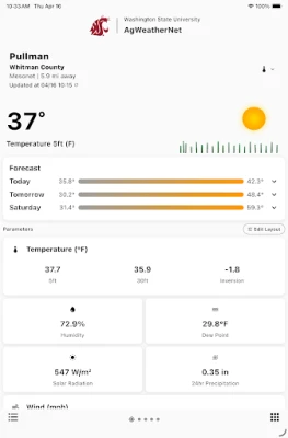
Current conditions from any AgWeatherNet station
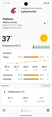
7-day forecasts with hourly breakdowns
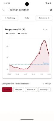
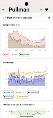
Meteogram visualizations for temperature, wind, humidity, precipitation, and solar radiation
Soil temperature and water potential at multiple depths
Agricultural Tools:
Crop evapotranspiration (ET) for 8 crop types including alfalfa, apple, cherry, grape, and potato
Daily reference ETo and ETr values
Spray guidance and Cattle Comfort Index (CCI)
Temperature inversion monitoring
Station Network:
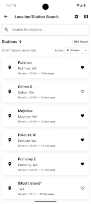
Interactive map with all AgWeatherNet stations
Search and filter stations by location or distance
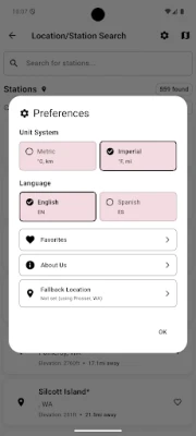
Save favorite stations for quick access
View station details including elevation, county etc..,
More Features:
Multi-station chart comparisons (up to 6 stations)
Home screen weather widgets
Light and dark mode support
Imperial and metric unit options
English and Spanish language support
Links to other AgWeatherNet tools and web portals
Weather Monitoring:
Current conditions from any AgWeatherNet station
7-day forecasts with hourly breakdowns
Meteogram visualizations for temperature, wind, humidity, precipitation, and solar radiation
Soil temperature and water potential at multiple depths
Agricultural Tools:
Crop evapotranspiration (ET) for 8 crop types including alfalfa, apple, cherry, grape, and potato
Daily reference ETo and ETr values
Spray guidance and Cattle Comfort Index (CCI)
Temperature inversion monitoring
Station Network:
Interactive map with all AgWeatherNet stations
Search and filter stations by location or distance
Save favorite stations for quick access
View station details including elevation, county etc..,
More Features:
Multi-station chart comparisons (up to 6 stations)
Home screen weather widgets
Light and dark mode support
Imperial and metric unit options
English and Spanish language support
Links to other AgWeatherNet tools and web portals
Rate the App
Add Comment & Review
User Reviews
Based on 0 reviews
No reviews added yet.
Comments will not be approved to be posted if they are SPAM, abusive, off-topic, use profanity, contain a personal attack, or promote hate of any kind.


More »

Popular Apps

phpFoxPHPFOX LLC

Moon Chai StoryOlha Dobel

World War Heroes — WW2 PvP FPSAzur Interactive Games Limited

Govee LiteGovee

Build World AdventureExplore city in cube world

Viking Clan: RagnarokKano Games

Vikings: War of ClansPlarium LLC

Asphalt 9: LegendsGameloft SE

Submarine Car Diving SimulatorSwim with dolphins & penguins

Dawn of Zombies: Survival GameRoyal Ark
More »
Editor's Choice

Grim Soul: Dark Survival RPGBrickworks Games Ltd

Craft of Survival - Gladiators101XP LIMITED

Last Shelter: SurvivalLong Tech Network Limited
Dawn of Zombies: Survival GameRoyal Ark

Merge Survival : WastelandStickyHands Inc.

AoD Vikings: Valhalla GameRoboBot Studio
Viking Clan: RagnarokKano Games
Vikings: War of ClansPlarium LLC
Asphalt 9: LegendsGameloft SE

Modern Tanks: War Tank GamesXDEVS LTD