
Latest Version
Version
7.8.8
7.8.8
Update
April 08, 2026
April 08, 2026
Developer
ATLOGIS Geoinformatics GmbH & Co. KG
ATLOGIS Geoinformatics GmbH & Co. KG
Categories
Maps & Navigation
Maps & Navigation
Platforms
Android
Android
Downloads
0
0
License
Free
Free
Package Name
com.atlogis.sweden
com.atlogis.sweden
Report
Report a Problem
Report a Problem
More About Sweden Topo Maps
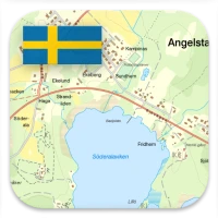
Sweden Topo Maps – Offline GPS Navigation for Outdoor Use
Turn your Android phone or tablet into a powerful offline GPS navigation system for Sweden. Perfect for hiking, cycling, and outdoor activities in areas without mobile coverage.
Explore detailed topographic maps, aerial imagery, and satellite maps with advanced navigation tools – similar to professional GPS devices.
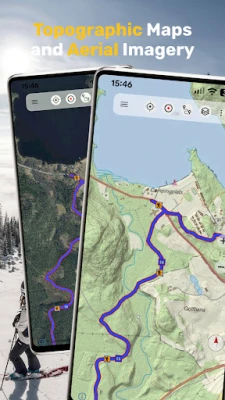
Topographic Maps and Aerial Imagery (Free)
Access high-quality maps for Sweden and worldwide:
• Lantmäteriet Topographic Maps (Topowebb, Terrängkartan, Fjällkartan) with high-resolution LiDAR hillshade
• Lantmäteriet Aerial Imagery
• 1:50,000 Topographic Maps for Scandinavia (Sweden, Norway, Finland, Denmark)
• AtloMaps OSM Maps with hillshading (worldwide)
• CyclOSM maps for cycling routes
• ESRI Topographic, Aerial, and Street Maps (online only)
• Google Maps and Satellite (online only)
• Bing Maps and Satellite (online only)
• Earth at Night
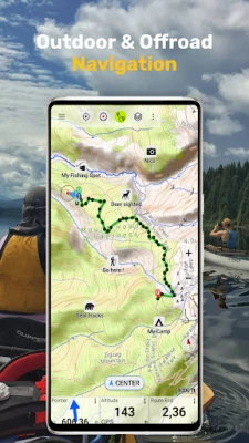
Outdoor GPS Navigation Features
Reliable navigation tools for outdoor use:
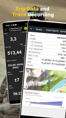
• Record GPS tracks with distance, speed, elevation, and accuracy
• Trip master with customizable data fields (speed, altitude, bearing, distance, etc.)
• Create and manage waypoints
• Go-to waypoint navigation
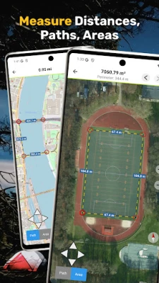
• Measure distances and areas
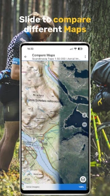
• Compare maps with transparency (fade between map layers)
• Search for places, addresses, and POIs
• Display coordinates in Lat/Lon, UTM, or MGRS/USNG
• Rotate map (North Up / Track Up)
• Get elevation and distance by tapping the map
• Track replay
• Export and share data (GPX, KML, KMZ)
Map Overlays (Free)
Enhance maps with additional layers:
• Hiking, cycling, MTB, and winter sports routes
• 10 m contour lines
• Hillshade overlay
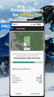
Pro Features (In-App Purchase)
Unlock advanced offline navigation:
• Full offline GPS navigation without mobile signal
• Bulk download of maps for offline use
• Route navigation with automatic routing (hiking and cycling profiles)
• Create and edit routes
• Import GPX, KML, KMZ files
• Unlimited waypoints and tracks
• Add custom map tile servers (WMS and raster maps)
• No ads
Offline Maps and Navigation
All viewed map tiles are cached automatically.
Download larger areas in advance and use the app completely offline without roaming costs.
Outdoor Activities
Ideal for hiking, cycling, MTB, camping, skiing, climbing, canoeing, aviation, hunting, off-road navigation, and search and rescue (SAR).
GPS Data and Formats
Create and use waypoints in Lat/Lon, UTM, or MGRS/USNG (WGS84).
Import, export, and share GPS data in GPX or Google Earth KML/KMZ format.
Privacy
No tracking. No data collection. Your location data stays on your device.
Support:
[email protected]
More apps: https://play.google.com/store/apps/developer?id=ATLOGIS+Geoinformatics+GmbH+%26+Co.+KG
Explore detailed topographic maps, aerial imagery, and satellite maps with advanced navigation tools – similar to professional GPS devices.
Topographic Maps and Aerial Imagery (Free)
Access high-quality maps for Sweden and worldwide:
• Lantmäteriet Topographic Maps (Topowebb, Terrängkartan, Fjällkartan) with high-resolution LiDAR hillshade
• Lantmäteriet Aerial Imagery
• 1:50,000 Topographic Maps for Scandinavia (Sweden, Norway, Finland, Denmark)
• AtloMaps OSM Maps with hillshading (worldwide)
• CyclOSM maps for cycling routes
• ESRI Topographic, Aerial, and Street Maps (online only)
• Google Maps and Satellite (online only)
• Bing Maps and Satellite (online only)
• Earth at Night
Outdoor GPS Navigation Features
Reliable navigation tools for outdoor use:
• Record GPS tracks with distance, speed, elevation, and accuracy
• Trip master with customizable data fields (speed, altitude, bearing, distance, etc.)
• Create and manage waypoints
• Go-to waypoint navigation
• Measure distances and areas
• Compare maps with transparency (fade between map layers)
• Search for places, addresses, and POIs
• Display coordinates in Lat/Lon, UTM, or MGRS/USNG
• Rotate map (North Up / Track Up)
• Get elevation and distance by tapping the map
• Track replay
• Export and share data (GPX, KML, KMZ)
Map Overlays (Free)
Enhance maps with additional layers:
• Hiking, cycling, MTB, and winter sports routes
• 10 m contour lines
• Hillshade overlay
Pro Features (In-App Purchase)
Unlock advanced offline navigation:
• Full offline GPS navigation without mobile signal
• Bulk download of maps for offline use
• Route navigation with automatic routing (hiking and cycling profiles)
• Create and edit routes
• Import GPX, KML, KMZ files
• Unlimited waypoints and tracks
• Add custom map tile servers (WMS and raster maps)
• No ads
Offline Maps and Navigation
All viewed map tiles are cached automatically.
Download larger areas in advance and use the app completely offline without roaming costs.
Outdoor Activities
Ideal for hiking, cycling, MTB, camping, skiing, climbing, canoeing, aviation, hunting, off-road navigation, and search and rescue (SAR).
GPS Data and Formats
Create and use waypoints in Lat/Lon, UTM, or MGRS/USNG (WGS84).
Import, export, and share GPS data in GPX or Google Earth KML/KMZ format.
Privacy
No tracking. No data collection. Your location data stays on your device.
Support:
[email protected]
More apps: https://play.google.com/store/apps/developer?id=ATLOGIS+Geoinformatics+GmbH+%26+Co.+KG
Rate the App
Add Comment & Review
User Reviews
Based on 0 reviews
No reviews added yet.
Comments will not be approved to be posted if they are SPAM, abusive, off-topic, use profanity, contain a personal attack, or promote hate of any kind.


More »

Popular Apps

Moon Chai StoryOlha Dobel

phpFoxPHPFOX LLC

Govee LiteGovee

World War Heroes — WW2 PvP FPSAzur Interactive Games Limited

Build World AdventureExplore city in cube world

Viking Clan: RagnarokKano Games

Vikings: War of ClansPlarium LLC

Asphalt 9: LegendsGameloft SE

Submarine Car Diving SimulatorSwim with dolphins & penguins

Union VPN - Secure VPN ProxyPureBrowser
More »
Editor's Choice

Grim Soul: Dark Survival RPGBrickworks Games Ltd

Craft of Survival - Gladiators101XP LIMITED

Last Shelter: SurvivalLong Tech Network Limited
Dawn of Zombies: Survival GameRoyal Ark

Merge Survival : WastelandStickyHands Inc.

AoD Vikings: Valhalla GameRoboBot Studio
Viking Clan: RagnarokKano Games
Vikings: War of ClansPlarium LLC
Asphalt 9: LegendsGameloft SE

Modern Tanks: War Tank GamesXDEVS LTD