
Latest Version
Update
May 19, 2026
May 19, 2026
Developer
Electric Pocket
Electric Pocket
Categories
Maps & Navigation
Maps & Navigation
Platforms
Android
Android
Downloads
0
0
License
Free
Free
Package Name
com.electricpocket.seanav
com.electricpocket.seanav
Report
Report a Problem
Report a Problem
More About SeaNav Boating navigation
Professional marine navigation with official charts, live AIS and advanced route planning. It’s like Google maps for your boat.
Plan, navigate and explore with high-resolution official marine charts covering US, Canada UK & IE, Europe and Australia.
SeaNav combines charts, routing, AIS and weather in one powerful , easy to use and affordable — navigation app.
Charts available with a free 3 day trial.
⸻
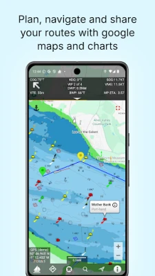
🧭 Plan Smarter
• Create and edit routes
• Auto-advance waypoints
• Measure distance & bearing
• Import & export GPX routes
• Works offline
⸻
⛵ Navigate with Confidence
• Real-time GPS navigation
• Course Up & North Up modes
• ETA, XTE, VMG, SOG & COG
• Sailing HUD display
• Background navigation
• Waypoint reached alerts
• MOB and Anchor alarm (IAP)
• Night mode display
⸻
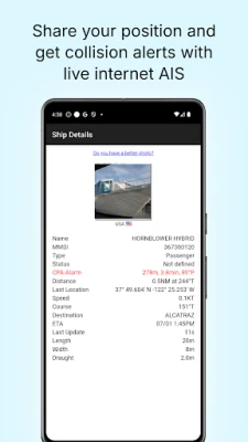
📡 Live AIS & Safety (Optional IAP)
• Real-time AIS ship positions
• Collision alarms
• AIS position sharing
• Internet AIS integration
• Free AIS when used with Boat Beacon
⸻
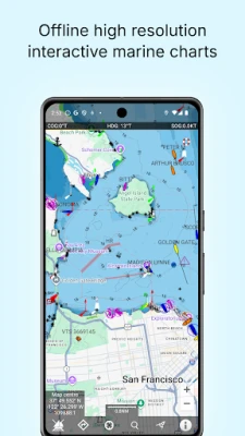
🌊 Charts & Marine Data
• Official high-resolution vector charts
• Seamless pan & zoom
• Buoys, lights, bridges & depths tappable
• Real-time distance & bearing to chart objects
• Configurable layers
• Satellite overlay
• NMEA instrument support (via Wifi or USB)
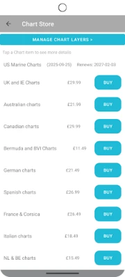
Charts available for:
US, Canada, BVI, Bermuda, UK & Ireland, Germany, France, Netherlands, Belgium, Norway, Spain, Croatia, Portugal, Sweden, Italy & Australia.
⸻
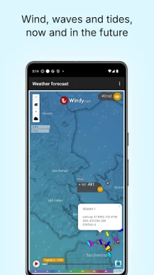
🌦 Weather & Tides (Optional IAP)
• Wind & wave forecasts (7 days)
• Tidal heights & tidal streams
• Moon & sun times
⸻
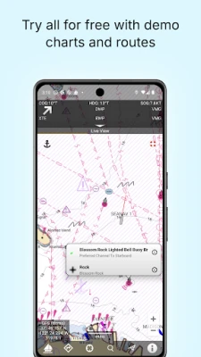
🎓 Try Everything Free
Built-in demo mode gives free access to charts, AIS, weather and tides.
The free version includes all route planning and navigation tools.
High-resolution vector charts are available via 12-month subscription including updates.
⸻
🔋 Requirements
• GPS required for live navigation
• Internet required for live AIS
• WiFi-only devices require external GPS
⸻
⚠ Important
Continued GPS use in background may reduce battery life.
⸻
📜 Legal
Contains material derived from UK Hydrographic Office data.
© British Crown Copyright.
Full Terms of Use:
http://seanav.net/termsofuse.php
Privacy Policy:
http://seanav.net/privacy.php
Support: [email protected]
SeaNav combines charts, routing, AIS and weather in one powerful , easy to use and affordable — navigation app.
Charts available with a free 3 day trial.
⸻
🧭 Plan Smarter
• Create and edit routes
• Auto-advance waypoints
• Measure distance & bearing
• Import & export GPX routes
• Works offline
⸻
⛵ Navigate with Confidence
• Real-time GPS navigation
• Course Up & North Up modes
• ETA, XTE, VMG, SOG & COG
• Sailing HUD display
• Background navigation
• Waypoint reached alerts
• MOB and Anchor alarm (IAP)
• Night mode display
⸻
📡 Live AIS & Safety (Optional IAP)
• Real-time AIS ship positions
• Collision alarms
• AIS position sharing
• Internet AIS integration
• Free AIS when used with Boat Beacon
⸻
🌊 Charts & Marine Data
• Official high-resolution vector charts
• Seamless pan & zoom
• Buoys, lights, bridges & depths tappable
• Real-time distance & bearing to chart objects
• Configurable layers
• Satellite overlay
• NMEA instrument support (via Wifi or USB)
Charts available for:
US, Canada, BVI, Bermuda, UK & Ireland, Germany, France, Netherlands, Belgium, Norway, Spain, Croatia, Portugal, Sweden, Italy & Australia.
⸻
🌦 Weather & Tides (Optional IAP)
• Wind & wave forecasts (7 days)
• Tidal heights & tidal streams
• Moon & sun times
⸻
🎓 Try Everything Free
Built-in demo mode gives free access to charts, AIS, weather and tides.
The free version includes all route planning and navigation tools.
High-resolution vector charts are available via 12-month subscription including updates.
⸻
🔋 Requirements
• GPS required for live navigation
• Internet required for live AIS
• WiFi-only devices require external GPS
⸻
⚠ Important
Continued GPS use in background may reduce battery life.
⸻
📜 Legal
Contains material derived from UK Hydrographic Office data.
© British Crown Copyright.
Full Terms of Use:
http://seanav.net/termsofuse.php
Privacy Policy:
http://seanav.net/privacy.php
Support: [email protected]
Rate the App
Add Comment & Review
User Reviews
Based on 0 reviews
No reviews added yet.
Comments will not be approved to be posted if they are SPAM, abusive, off-topic, use profanity, contain a personal attack, or promote hate of any kind.


More »

Popular Apps

phpFoxPHPFOX LLC

Moon Chai StoryOlha Dobel

World War Heroes — WW2 PvP FPSAzur Interactive Games Limited

Govee LiteGovee

Build World AdventureExplore city in cube world

Viking Clan: RagnarokKano Games

Vikings: War of ClansPlarium LLC

Submarine Car Diving SimulatorSwim with dolphins & penguins

Asphalt 9: LegendsGameloft SE

Dawn of Zombies: Survival GameRoyal Ark
More »
Editor's Choice

Grim Soul: Dark Survival RPGBrickworks Games Ltd

Craft of Survival - Gladiators101XP LIMITED

Last Shelter: SurvivalLong Tech Network Limited
Dawn of Zombies: Survival GameRoyal Ark

Merge Survival : WastelandStickyHands Inc.

AoD Vikings: Valhalla GameRoboBot Studio
Viking Clan: RagnarokKano Games
Vikings: War of ClansPlarium LLC
Asphalt 9: LegendsGameloft SE

Modern Tanks: War Tank GamesXDEVS LTD